|
search place name
|
||
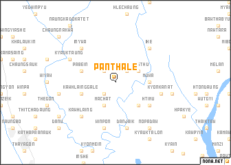
Panthale (Myanmar)Panthale is a town in Myanmar. An overview map of the region around Panthale is displayed below.
regional and 3d topo map of Panthale, Myanmar ::
Panthale airports ::
The nearest airport is RGN - Yangon Intl, located 143.6 km west of Panthale.
Nearby towns ::
Peinnedaw (2.6km north east) //
Minlwin (2.6km north west) //
Sizon (2.6km south west) //
Taungthu (4.0km north east) //
Machat (4.1km south west) //
Shaukkon (5.1km south east) //
Muwa (5.3km east) //
Pabein (5.6km west) //
Kawhlainggale (5.6km west) //
Htimu (6.5km south east) //
Kyonkanat (7.3km east) //
Thebyuseik (7.6km south) //
Danjaik (7.6km south) //
Winpon (7.6km south) //
I-he (7.7km north east) //
In-ywa (7.7km north west) //
Kawhlaing (7.7km south west) //
Kyauktaung (8.0km north west) //
Saung-e (8.0km north west) //
Nopadaw (9.1km south east) //
[all distances 'as the bird flies' and approximate]  Places with similar names to Panthale, Myanmar ::
// Pinthila (MM)
// Peinthal (AT)
// Point Hill (US)
// Painthal (IN)
// Pūnthil (IN)
// Point Hill (JM)
// Ponthoile (FR)
// Paint Hill (US)
Disclaimer :: Information on this page comes without warranty of any kind |
||
|
Where is Panthale? Elevation and coordinates ::
Latitude (lat): 17°6'0"N Longitude (lon): 97°28'0"E
Elevation (approx.): 8m (map arrows pan, magnifying glasses zoom) |
||
|
Visiting Panthale? Hotel/Accommodation ::
Book a hotel in Panthale Travel Guide ::
Buy a travel guide for Myanmar rental cars ::
car rental offers GPS waypoint ::
download a GPX waypoint (PoI) of Panthale for your GPS receiver
|
||