|
search place name
|
||
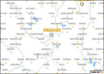
Paukkon (Ayeyarwady, Myanmar)Paukkon is a town in the Ayeyarwady region of Myanmar. An overview map of the region around Paukkon is displayed below.
regional and 3d topo map of Paukkon, Myanmar ::
Paukkon airports ::
The nearest airport is RGN - Yangon Intl, located 126.8 km south east of Paukkon.
Other airports nearby include SNW - Thandwe (139.3 km north west), KYP - Kyaukpyu (273.2 km north west), Nearby towns ::
Thaunggyi (1.9km south) //
Tagyo (2.6km south east) //
Kyontha (4.1km south east) //
Bokchaung (4.1km north east) //
Mezali (4.1km north east) //
Taseik (4.0km south west) //
Kongale (4.0km north east) //
Ngathainggyaung (5.6km south) //
Kyaukchaung (5.3km west) //
Daunggyi (5.8km south) //
Kyatkwin (5.6km east) //
Yelegyi (5.6km east) //
Zatzu (7.1km west) //
Yinze (7.4km north) //
Zinbyungon (7.7km north east) //
Ketkugale (7.7km north west) //
Yathagyi (8.0km north west) //
Shanzu (8.0km north east) //
Thayetchaung (8.2km south west) //
Kalagon (9.0km north west) //
Shanywagyi (9.1km north east) //
Alezu (10.2km north west) //
[all distances 'as the bird flies' and approximate]  Places with similar names to Paukkon, Myanmar ::
Disclaimer :: Information on this page comes without warranty of any kind |
||
|
Where is Paukkon? Elevation and coordinates ::
Latitude (lat): 17°27'0"N Longitude (lon): 95°5'0"E
Elevation (approx.): 4m (map arrows pan, magnifying glasses zoom) |
||
|
Visiting Paukkon? Hotel/Accommodation ::
Book a hotel in Paukkon Travel Guide ::
Buy a travel guide for Myanmar rental cars ::
car rental offers GPS waypoint ::
download a GPX waypoint (PoI) of Paukkon for your GPS receiver
|
||