|
search place name
|
||
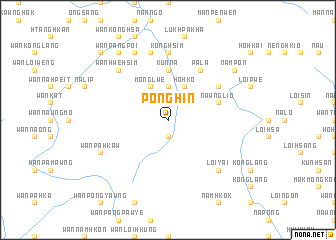
Ponghin (Shan, Myanmar)Ponghin is a town in the Shan region of Myanmar. An overview map of the region around Ponghin is displayed below.
regional and 3d topo map of Ponghin, Myanmar ::
Ponghin airports ::
The nearest airport is LSH - Lashio, located 120.7 km north of Ponghin.
Other airports nearby include HEH - Heho (148.0 km south west), MDL - Mandalay Intl (157.5 km west), MOG - Mong Hsat (240.7 km south east), Nearby towns ::
Hpakpong (1.9km north) //
Hsa-taw (1.9km south) //
Pa-mawng (1.9km south) //
Pangniu (2.5km north east) //
Namkat (3.7km north) //
Mong Lwe (4.1km north west) //
Ho-hko (4.1km north east) //
Kunna (5.6km north) //
Taw-sengka (5.6km north) //
Nawng Lio (5.5km east) //
Nawng Leng (6.4km north east) //
Pa-la (6.5km north east) //
Konghsim (7.4km north) //
Tonglau (7.6km north) //
Loi-yai (7.6km south east) //
Wān Hwè-hsim (7.6km north west) //
Wān Nammawhson (8.2km north west) //
Wān Pa-hkaw (7.8km south west) //
Wān Pangpoi (9.0km north west) //
Nam Pon (8.8km north east) //
Wān Longlan (10.1km north west) //
[all distances 'as the bird flies' and approximate] 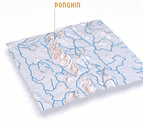 Places with similar names to Ponghin, Myanmar ::
Disclaimer :: Information on this page comes without warranty of any kind |
||
|
Where is Ponghin? Elevation and coordinates ::
Latitude (lat): 21°55'0"N Longitude (lon): 97°29'0"E
Elevation (approx.): 716m (map arrows pan, magnifying glasses zoom) |
||
|
Visiting Ponghin? Hotel/Accommodation ::
Book a hotel in Ponghin Travel Guide ::
Buy a travel guide for Myanmar rental cars ::
car rental offers GPS waypoint ::
download a GPX waypoint (PoI) of Ponghin for your GPS receiver
|
||