|
search place name
|
||
Sado (Mandalay, Myanmar)Sado is a town in the Mandalay region of Myanmar. An overview map of the region around Sado is displayed below.
regional and 3d topo map of Sado, Myanmar ::

Sado airports ::
The nearest airport is MDL - Mandalay Intl, located 18.2 km south west of Sado.
Other airports nearby include HEH - Heho (141.0 km south east), LSH - Lashio (213.5 km north east), Nearby towns ::
Letthamagu (0.0km north) //
Mingaing (1.9km south) //
Nyaungbinzauk (1.9km south) //
Inhlya (2.5km south west) //
Odeindaung (3.7km south) //
Myitnge (3.7km north) //
Nayagan (3.7km north) //
Paleik (3.9km south west) //
Leiksangun (3.9km south west) //
Myaukkaing (3.9km north west) //
Yegyibauk (3.9km north west) //
Sauktawwa (3.9km north east) //
Talingyi (5.1km south east) //
Shwebaukpin (5.2km east) //
Magyigaing (5.2km east) //
Taungthaman (5.8km north) //
Nwanozu (5.8km north) //
Seywa (5.8km south) //
Kinlat (5.8km south) //
Taunggaing (6.4km south east) //
Bon-o (6.4km north west) //
Ywahaunggon (7.4km south) //
Nyaungbingyi (7.4km south) //
Uyingale (6.9km west) //
Chinywa (6.9km west) //
Taungmingyi (7.4km north) //
Tatkyi (7.1km west) //
Tagundaing (7.6km north) //
Tamokso (7.1km east) //
[all distances 'as the bird flies' and approximate] 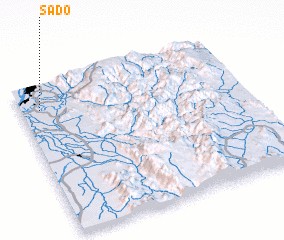 Places with similar names to Sado, Myanmar ::
Disclaimer :: Information on this page comes without warranty of any kind |
||
|
Where is Sado? Elevation and coordinates ::
Latitude (lat): 21°50'0"N Longitude (lon): 96°5'0"E
Elevation (approx.): 75m (map arrows pan, magnifying glasses zoom) |
||
|
Visiting Sado? Hotel/Accommodation ::
Book a hotel in Sado Travel Guide ::
Buy a travel guide for Myanmar rental cars ::
car rental offers GPS waypoint ::
download a GPX waypoint (PoI) of Sado for your GPS receiver
|
||