|
search place name
|
||
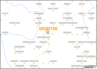
Sakantha (Shan, Myanmar)Sakantha is a town in the Shan region of Myanmar. An overview map of the region around Sakantha is displayed below.
regional and 3d topo map of Sakantha, Myanmar ::
Sakantha airports ::
The nearest airport is LSH - Lashio, located 98.6 km north east of Sakantha.
Other airports nearby include MDL - Mandalay Intl (132.6 km south west), HEH - Heho (191.3 km south), Nearby towns ::
Pyawnghkawng (1.7km east) //
Na-mu-htwai (1.9km south) //
Mān Sakanhsa (1.7km west) //
Mān Maklawngkwan (2.5km north west) //
Haw Sakanhsa (2.5km south west) //
Na-ai-hkant (3.7km south) //
Pangti (4.1km north east) //
Panghai (4.1km south west) //
Kutawn (5.0km north west) //
Namsaw (5.8km north) //
Hkomung (6.3km north east) //
Hwèpu (6.5km north west) //
Kio-sam (6.5km south west) //
Pawk-ang (6.9km east) //
Loi-ung (7.4km south) //
Loi-ngup (7.6km south) //
Mansawnpōng (7.6km north west) //
Kawngmuleng (7.6km south west) //
Hpwèhung (8.2km north west) //
Nàmon (8.2km north west) //
Mān Na-hkawng (7.8km south west) //
Pengnim (8.8km north east) //
Kywaiköng (8.8km north east) //
Taunghnauk (9.0km north east) //
Kyaukme (10.1km north east) //
[all distances 'as the bird flies' and approximate]  Places with similar names to Sakantha, Myanmar :: Disclaimer :: Information on this page comes without warranty of any kind |
||
|
Where is Sakantha? Elevation and coordinates ::
Latitude (lat): 22°28'0"N Longitude (lon): 96°58'0"E
Elevation (approx.): 888m (map arrows pan, magnifying glasses zoom) |
||
|
Visiting Sakantha? Hotel/Accommodation ::
Book a hotel in Sakantha Travel Guide ::
Buy a travel guide for Myanmar rental cars ::
car rental offers GPS waypoint ::
download a GPX waypoint (PoI) of Sakantha for your GPS receiver
|
||