|
search place name
|
||
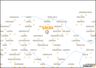
Sakaw (Shan, Myanmar)Sakaw is a town in the Shan region of Myanmar. An overview map of the region around Sakaw is displayed below.
regional and 3d topo map of Sakaw, Myanmar ::
Sakaw airports ::
The nearest airport is LSH - Lashio, located 131.3 km south west of Sakaw.
Other airports nearby include MYT - Myitkyina (176.1 km north west), Nearby towns ::
Mān Chak (1.9km north) //
Mān Kang (2.5km north west) //
Hsunka (2.5km north west) //
Panglom (2.5km south east) //
Mān Maw (3.7km north) //
Hsin-chai (3.4km east) //
Hkopawng (3.9km north west) //
Kawnhsam (3.9km south west) //
Panghkawn (4.1km south west) //
Hsawka (4.1km south east) //
Hpau-sung (3.9km north east) //
E-hku (3.9km north east) //
Hsinsai-htang (3.9km south east) //
Panghkawn (5.0km south west) //
Mān Kang (5.1km east) //
Mān Kung (5.6km north) //
Namhpa (5.4km east) //
Panghkawn (5.8km south) //
Panglong (5.8km north) //
Mān Maü (6.3km north west) //
Hpawmaw (6.3km north west) //
Kawnglong (6.3km north east) //
Loi-kang (6.5km south east) //
Wachong (6.8km east) //
Namhpe (7.0km west) //
Namhsu (7.5km north west) //
Lawku (7.7km north west) //
Pangsong (7.7km south west) //
Panghsak (8.1km south east) //
[all distances 'as the bird flies' and approximate]  Places with similar names to Sakaw, Myanmar ::
Disclaimer :: Information on this page comes without warranty of any kind |
||
|
Where is Sakaw? Elevation and coordinates ::
Latitude (lat): 24°3'0"N Longitude (lon): 98°18'0"E
Elevation (approx.): 1671m (map arrows pan, magnifying glasses zoom) |
||
|
Visiting Sakaw? Hotel/Accommodation ::
Book a hotel in Sakaw Travel Guide ::
Buy a travel guide for Myanmar rental cars ::
car rental offers GPS waypoint ::
download a GPX waypoint (PoI) of Sakaw for your GPS receiver
|
||