|
search place name
|
||
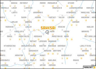
Sawk Sai (Shan, Myanmar)Sawk Sai is a town in the Shan region of Myanmar. An overview map of the region around Sawk Sai is displayed below.
regional and 3d topo map of Sawk Sai, Myanmar ::
Sawk Sai airports ::
The nearest airport is HEH - Heho, located 47.7 km west of Sawk Sai.
Other airports nearby include MDL - Mandalay Intl (169.0 km north west), Nearby towns ::
Pāngpeng (1.9km south) //
Ho-na (1.7km east) //
Linhka (1.7km west) //
Loi-se-ti (2.5km north east) //
Nampa-chi (2.5km north west) //
Mong Hko (3.9km south west) //
Pangta-hka (3.9km south east) //
Pang Ta Hka (3.9km south east) //
Mān Mai (3.9km north west) //
Long Sam (4.1km south west) //
Nawngko (4.1km south east) //
Mān Hitmawng (5.5km west) //
Hkoche (5.5km east) //
Ywathit (5.8km north) //
Hwe-tak (5.8km south) //
Hwe Howe (5.8km south) //
Ho-nam (5.8km north) //
Makti (5.8km north) //
Pat-dat (6.4km south west) //
Mönglawng (6.6km north west) //
Kunna (6.6km north west) //
Tadagyi (6.9km west) //
Tawngloi (7.4km north) //
Pawngleng (6.9km west) //
Kan Na (6.9km east) //
Mongnoi (7.4km south) //
Sao-ngao (6.9km east) //
Loi-lun (7.2km west) //
Ho-na (7.2km east) //
[all distances 'as the bird flies' and approximate]  Places with similar names to Sawk Sai, Myanmar ::
Disclaimer :: Information on this page comes without warranty of any kind |
||
|
Where is Sawk Sai? Elevation and coordinates ::
Latitude (lat): 20°45'0"N Longitude (lon): 97°15'0"E
Elevation (approx.): 1169m (map arrows pan, magnifying glasses zoom) |
||
|
Visiting Sawk Sai? Hotel/Accommodation ::
Book a hotel in Sawk Sai Travel Guide ::
Buy a travel guide for Myanmar rental cars ::
car rental offers GPS waypoint ::
download a GPX waypoint (PoI) of Sawk Sai for your GPS receiver
|
||