|
search place name
|
||
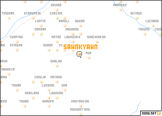
Sawnkyawn (Kachin State, Myanmar)Sawnkyawn is a town in the Kachin State region of Myanmar. An overview map of the region around Sawnkyawn is displayed below.
regional and 3d topo map of Sawnkyawn, Myanmar ::
Sawnkyawn airports ::
The nearest airport is MYT - Myitkyina, located 83.7 km south west of Sawnkyawn.
Other airports nearby include PBU - Putao (195.0 km north), Nearby towns ::
Mum (1.7km east) //
Ritsang (2.5km north west) //
Yindam (3.8km north west) //
Laungkaw (4.1km north west) //
Rgangpi (5.0km north east) //
Shachinpok (5.0km north east) //
Tunhpaung (5.6km north) //
Talam (5.6km north) //
Shalaw (5.3km west) //
Shalaw (5.3km west) //
Magawng (5.8km north) //
Matao (6.2km north west) //
Aukan (7.4km north) //
Sha-on (6.9km west) //
Nayang (7.5km south west) //
Uma (8.1km south west) //
Pangli (8.1km north west) //
Luksing (10.0km south west) //
[all distances 'as the bird flies' and approximate]  Places with similar names to Sawnkyawn, Myanmar ::
// Sankyein (MM)
// Sawnkyun (MM)
// Sengayan (MY)
// Singayan (MY)
// Sangoyana (ZA)
// Singayen (PH)
// Sungayon (PH)
// Zānkyun (MM)
// Sơn Nguyễn (VN)
// Xuan Nguyên (VN)
Disclaimer :: Information on this page comes without warranty of any kind |
||
|
Where is Sawnkyawn? Elevation and coordinates ::
Latitude (lat): 25°41'0"N Longitude (lon): 98°7'0"E
Elevation (approx.): 1356m (map arrows pan, magnifying glasses zoom) |
||
|
Visiting Sawnkyawn? Hotel/Accommodation ::
Book a hotel in Sawnkyawn Travel Guide ::
Buy a travel guide for Myanmar rental cars ::
car rental offers GPS waypoint ::
download a GPX waypoint (PoI) of Sawnkyawn for your GPS receiver
|
||