|
search place name
|
||
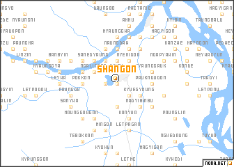
Shangon (Myanmar)Shangon is a town in Myanmar. An overview map of the region around Shangon is displayed below.
regional and 3d topo map of Shangon, Myanmar ::
Shangon airports ::
The nearest airport is KYP - Kyaukpyu, located 171.9 km south west of Shangon.
Other airports nearby include MDL - Mandalay Intl (186.6 km north east), AKY - Sittwe (191.7 km west), Nearby towns ::
Pabezu (0.0km north) //
Shanzu (0.0km north) //
Minyingon (1.9km north) //
Kyizu (1.9km north) //
Kandaung (1.7km west) //
Salin (2.5km north east) //
Dattawkada (2.5km south east) //
Kayegon (3.7km north) //
Uyinzu (3.7km north) //
Wetthaik (3.7km south) //
Ngalinban (3.9km north west) //
Shwedwindu (3.9km north west) //
Kywegyaung (3.9km south east) //
Myemigon (4.1km north east) //
Aukhlaing (4.1km north west) //
Yinmabya (5.1km north west) //
Sanegyaung (5.1km north west) //
Magyibinbu (5.1km south east) //
Sethushingon (5.1km south east) //
Paukngugon (5.2km east) //
Naungdaw (5.6km north) //
Tandawgyi (5.6km north) //
Pokkon (5.2km west) //
Myaunggauk (5.5km east) //
Gwebinzin (5.5km west) //
Paungse (5.5km west) //
Padeingon (5.8km north) //
Kanywa (5.8km south) //
Kyaukyedon (5.8km north) //
[all distances 'as the bird flies' and approximate] 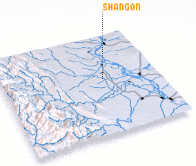 Places with similar names to Shangon, Myanmar ::
Disclaimer :: Information on this page comes without warranty of any kind |
||
|
Where is Shangon? Elevation and coordinates ::
Latitude (lat): 20°34'0"N Longitude (lon): 94°39'0"E
Elevation (approx.): 73m (map arrows pan, magnifying glasses zoom) |
||
|
Visiting Shangon? Hotel/Accommodation ::
Book a hotel in Shangon Travel Guide ::
Buy a travel guide for Myanmar rental cars ::
car rental offers GPS waypoint ::
download a GPX waypoint (PoI) of Shangon for your GPS receiver
|
||