|
search place name
|
||
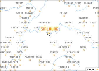
Sinlaung (Sagaing, Myanmar)Sinlaung is a town in the Sagaing region of Myanmar. An overview map of the region around Sinlaung is displayed below.
regional and 3d topo map of Sinlaung, Myanmar ::
Sinlaung airports ::
The nearest airport is IMF - Imphal, located 175.3 km north west of Sinlaung.
Other airports nearby include MYT - Myitkyina (241.5 km north east), Nearby towns ::
Kangon (1.9km north) //
Katpanbok (3.9km north west) //
Aungbingon (4.1km north west) //
Pangu (4.1km south east) //
Hethat (4.1km south east) //
Seintgyi (7.6km south) //
Maleindon (7.5km south east) //
Sunpha (7.7km north east) //
Pindon (7.7km south east) //
Pathet (9.0km north east) //
Aunggon (10.0km north west) //
[all distances 'as the bird flies' and approximate]  Places with similar names to Sinlaung, Myanmar ::
// Sanlong (MM)
// Senlung (MM)
// Sinhlaung (MM)
// Sinlu-aing (MM)
// Sinluaing (MM)
// Sinlung Ga (MM)
// Son Laing (MM)
// Snelling (US)
// Senaling (MY)
// Snelling (US)
Disclaimer :: Information on this page comes without warranty of any kind |
||
|
Where is Sinlaung? Elevation and coordinates ::
Latitude (lat): 24°4'0"N Longitude (lon): 95°27'0"E
Elevation (approx.): 288m (map arrows pan, magnifying glasses zoom) |
||
|
Visiting Sinlaung? Hotel/Accommodation ::
Book a hotel in Sinlaung Travel Guide ::
Buy a travel guide for Myanmar rental cars ::
car rental offers GPS waypoint ::
download a GPX waypoint (PoI) of Sinlaung for your GPS receiver
|
||