|
search place name
|
||
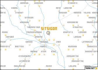
Sitsi-gôn (Shan, Myanmar)Sitsi-gôn is a town in the Shan region of Myanmar. An overview map of the region around Sitsi-gôn is displayed below.
regional and 3d topo map of Sitsi-gôn, Myanmar ::
Sitsi-gôn airports ::
The nearest airport is MDL - Mandalay Intl, located 96.1 km south west of Sitsi-gôn.
Other airports nearby include LSH - Lashio (134.9 km north east), HEH - Heho (166.7 km south), Nearby towns ::
Na-kyaung-kham (1.9km south) //
Kontha (2.5km south east) //
Na-kaw (2.5km south west) //
The-khaw (4.1km south west) //
Paung-aw (4.1km south east) //
On-ma-thi (3.9km south west) //
Zi-bin (5.1km south east) //
Mang Leng (5.1km west) //
Taung-gaung-bwe (5.1km west) //
Tha-pangyaung (5.5km west) //
Kon-gyi (5.8km south) //
Hu-hkai (6.3km north east) //
Namkinli (6.5km north west) //
Hsapyeto (6.9km east) //
Kyu-in (7.6km south) //
In-win (7.6km south) //
Gan-kaw (7.8km south west) //
Mi-nyankung (7.8km north west) //
Nyaung-gon (8.2km south west) //
Kongson (9.0km north east) //
Banbwe (9.0km south west) //
Sitke-gon (8.8km north west) //
Myenphyu (8.8km south east) //
[all distances 'as the bird flies' and approximate]  Places with similar names to Sitsi-gôn, Myanmar ::
Disclaimer :: Information on this page comes without warranty of any kind |
||
|
Where is Sitsi-gôn? Elevation and coordinates ::
Latitude (lat): 22°15'0"N Longitude (lon): 96°42'0"E
Elevation (approx.): 717m (map arrows pan, magnifying glasses zoom) |
||
|
Visiting Sitsi-gôn? Hotel/Accommodation ::
Book a hotel in Sitsi-gôn Travel Guide ::
Buy a travel guide for Myanmar rental cars ::
car rental offers GPS waypoint ::
download a GPX waypoint (PoI) of Sitsi-gôn for your GPS receiver
|
||