|
search place name
|
||
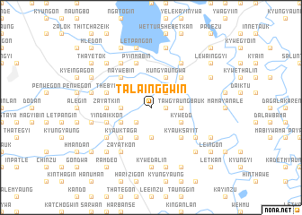
Talainggwin (Myanmar)Talainggwin is a town in Myanmar. An overview map of the region around Talainggwin is displayed below.
regional and 3d topo map of Talainggwin, Myanmar ::
Talainggwin airports ::
The nearest airport is RGN - Yangon Intl, located 153.2 km south of Talainggwin.
Nearby towns ::
Kyaungywa (1.8km east) //
Po Ta (2.6km north east) //
Daungmo (2.6km north east) //
Nanzatgyi (2.6km south west) //
Tawgyaungbauk (3.5km east) //
Pyanthalin (3.7km south) //
Paukkon (3.5km west) //
Nanzatgale (3.5km west) //
Thaungbu (4.0km south east) //
Kywedo (4.0km south east) //
Ananbaw (4.1km north east) //
Kungyaungwa (4.1km north east) //
Bawdigwin (4.1km south west) //
Thingangyun (4.1km south west) //
Thon-einzu (4.1km south west) //
Sinyogin (4.0km south west) //
Kyauksayit (5.1km south east) //
Nathangwin (5.1km north east) //
Kyauktaga (5.1km south west) //
Naywèbin (5.1km north west) //
Zayatkin (5.3km west) //
Pyinmabin (5.8km north) //
Yindaikkon (5.6km west) //
Thèbyu (5.6km west) //
Indainggon (6.5km south east) //
Yedwingon Auk (6.6km north east) //
Yedwingon Ale (6.6km north east) //
Yedwingon Atet (6.6km north east) //
Yedwingon (6.6km north east) //
[all distances 'as the bird flies' and approximate]  Places with similar names to Talainggwin, Myanmar ::
Disclaimer :: Information on this page comes without warranty of any kind |
||
|
Where is Talainggwin? Elevation and coordinates ::
Latitude (lat): 18°12'0"N Longitude (lon): 96°39'0"E
Elevation (approx.): 19m (map arrows pan, magnifying glasses zoom) |
||
|
Visiting Talainggwin? Hotel/Accommodation ::
Book a hotel in Talainggwin Travel Guide ::
Buy a travel guide for Myanmar rental cars ::
car rental offers GPS waypoint ::
download a GPX waypoint (PoI) of Talainggwin for your GPS receiver
|
||