|
search place name
|
||
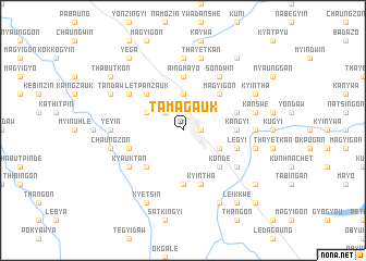
Tamagauk (Mandalay, Myanmar)Tamagauk is a town in the Mandalay region of Myanmar. An overview map of the region around Tamagauk is displayed below.
regional and 3d topo map of Tamagauk, Myanmar ::
Tamagauk airports ::
The nearest airport is MDL - Mandalay Intl, located 75.6 km north east of Tamagauk.
Other airports nearby include HEH - Heho (126.7 km east), Nearby towns ::
Mahlaing (1.7km east) //
Shawbyugon (2.5km north west) //
Kangale (2.5km north west) //
Tanaunggyin (3.7km north) //
Yeni (3.9km north west) //
Zibingan (3.9km south east) //
Letpanzauk (5.1km north west) //
Monbin (5.1km south west) //
Magyigon (5.1km north east) //
Konde (5.1km south east) //
Kangyi (5.2km east) //
Aingmayo (5.6km north) //
Wakyungan (5.6km south) //
Thegan (5.5km east) //
Yingwe (5.5km west) //
Legyi (5.5km east) //
Kyintha (5.8km south) //
Yedwet (6.4km north west) //
Ywadan (6.4km south east) //
Theingon (6.4km south east) //
Mongan (6.4km south west) //
Kyauktan (6.4km south west) //
Paungyodaw (6.4km south east) //
Sondwin (6.5km north east) //
Yeyin (6.9km west) //
Hnawdaw (7.4km north) //
Myetthigyin (6.9km east) //
Ywathit (7.2km west) //
Thegyun (7.2km west) //
[all distances 'as the bird flies' and approximate]  Places with similar names to Tamagauk, Myanmar ::
// Damacuag (PH)
// Dumaguk (PH)
// Tamagauk (MM)
// Tamagauk (MM)
// Tamagauk (MM)
// Damkoko (BF)
// Damkoko (BF)
// Tamba-Kaka (CD)
// Tomokoko (CD)
// Tambo-guaico (EC)
Disclaimer :: Information on this page comes without warranty of any kind |
||
|
Where is Tamagauk? Elevation and coordinates ::
Latitude (lat): 21°6'0"N Longitude (lon): 95°38'0"E
Elevation (approx.): 302m (map arrows pan, magnifying glasses zoom) |
||
|
Visiting Tamagauk? Hotel/Accommodation ::
Book a hotel in Tamagauk Travel Guide ::
Buy a travel guide for Myanmar rental cars ::
car rental offers GPS waypoint ::
download a GPX waypoint (PoI) of Tamagauk for your GPS receiver
|
||