|
search place name
|
||
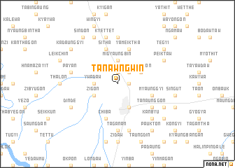
Ta-nawngwin (Sagaing, Myanmar)Ta-nawngwin is a town in the Sagaing region of Myanmar. An overview map of the region around Ta-nawngwin is displayed below.
regional and 3d topo map of Ta-nawngwin, Myanmar ::
Ta-nawngwin airports ::
The nearest airport is MDL - Mandalay Intl, located 104.0 km south of Ta-nawngwin.
Other airports nearby include HEH - Heho (235.1 km south east), Nearby towns ::
Obingon (1.9km north) //
U-yindaw (1.7km east) //
Onbingon (2.5km north east) //
Ywadaw (3.4km west) //
Migyaungbin (3.7km north) //
Zigon (3.9km south west) //
Shwebo (4.1km south east) //
Kyaukkon (3.9km north east) //
Sitha (5.8km north) //
Chiba (5.8km south) //
Nyaunggyigon (5.5km east) //
Myaunggyi (5.5km east) //
Yameiktha (5.8km north) //
Ta-naunggon (6.3km south east) //
Pokkon (7.4km north) //
Taganan (7.4km south) //
Payan (7.1km west) //
Kyettet (7.6km north) //
Shadaw (7.6km south) //
Tagundaing (7.6km south east) //
Kanbyu (7.6km south east) //
Dindè (7.8km south west) //
Myingatha (8.2km north west) //
Peiktaw (7.8km north east) //
Mingyaung (7.8km south east) //
Kadaunggyi (8.8km north west) //
Sindon (9.0km north west) //
Tegyi (8.8km north east) //
Shwegu (8.8km south east) //
[all distances 'as the bird flies' and approximate] 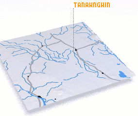 Places with similar names to Ta-nawngwin, Myanmar ::
Disclaimer :: Information on this page comes without warranty of any kind |
||
|
Where is Ta-nawngwin? Elevation and coordinates ::
Latitude (lat): 22°36'0"N Longitude (lon): 95°41'0"E
Elevation (approx.): 112m (map arrows pan, magnifying glasses zoom) |
||
|
Visiting Ta-nawngwin? Hotel/Accommodation ::
Book a hotel in Ta-nawngwin Travel Guide ::
Buy a travel guide for Myanmar rental cars ::
car rental offers GPS waypoint ::
download a GPX waypoint (PoI) of Ta-nawngwin for your GPS receiver
|
||