|
search place name
|
||
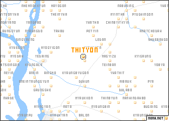
Thityon (Mandalay, Myanmar)Thityon is a town in the Mandalay region of Myanmar. An overview map of the region around Thityon is displayed below.
regional and 3d topo map of Thityon, Myanmar ::
Thityon airports ::
The nearest airport is MDL - Mandalay Intl, located 55.0 km east of Thityon.
Other airports nearby include HEH - Heho (164.9 km south east), Nearby towns ::
Zibingan (0.0km north) //
Kyaukkan (2.5km north east) //
Kyaungbyugan (4.1km south west) //
Taywinbo (4.1km south west) //
Ledan (5.1km north east) //
Tatywa (5.1km north east) //
Magyizu (5.2km east) //
Duwun (5.6km south) //
Ywathaya (5.5km east) //
Petyin (5.8km north) //
Teinban (5.5km east) //
Kokke (6.4km north east) //
Ywatha (7.6km north) //
Myogyigon (7.1km west) //
Kyibingan (7.6km south east) //
Yondozwe (7.6km south east) //
Tawbu (7.6km north west) //
Okshitkon (7.8km south east) //
Ywathit (7.8km south east) //
Aingma (7.8km south west) //
Pyogan (8.9km south east) //
Kanywa (8.9km south west) //
Chinbyitkyin (10.1km north east) //
[all distances 'as the bird flies' and approximate] 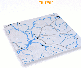 Places with similar names to Thityon, Myanmar ::
// Thọ Duyên (VN)
Disclaimer :: Information on this page comes without warranty of any kind |
||
|
Where is Thityon? Elevation and coordinates ::
Latitude (lat): 21°34'0"N Longitude (lon): 95°28'0"E
Elevation (approx.): 112m (map arrows pan, magnifying glasses zoom) |
||
|
Visiting Thityon? Hotel/Accommodation ::
Book a hotel in Thityon Travel Guide ::
Buy a travel guide for Myanmar rental cars ::
car rental offers GPS waypoint ::
download a GPX waypoint (PoI) of Thityon for your GPS receiver
|
||