|
search place name
|
||
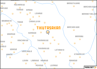
Tikuta Sakan (Kayin, Myanmar)Tikuta Sakan is a town in the Kayin region of Myanmar. An overview map of the region around Tikuta Sakan is displayed below.
regional and 3d topo map of Tikuta Sakan, Myanmar ::
Tikuta Sakan airports ::
The nearest airport is RGN - Yangon Intl, located 207.2 km south west of Tikuta Sakan.
Nearby towns ::
Klawkhido (1.9km south east) //
Supido (2.3km north) //
Thathwedo (3.0km west) //
Kawlawdo (3.1km south east) //
Pawlawdo (3.5km south) //
Thikawmudo (3.9km south west) //
Winawdö (4.9km north) //
Yuwado (5.2km south east) //
Kumawdo (5.8km west) //
Mimawdo (5.9km west) //
Chawklukhi (6.3km north west) //
Thikawmudo (6.7km south) //
Leiwado (7.9km north west) //
Lethawko (8.2km south east) //
Htauyado (9.0km south) //
Peinnebin Sakan (8.8km north west) //
Pateido (9.0km north west) //
Hipodo (10.8km north west) //
Kaiklawdo (10.9km south west) //
Padedo (11.0km north west) //
Nawwedo (11.5km south east) //
[all distances 'as the bird flies' and approximate] 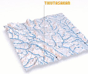 Places with similar names to Tikuta Sakan, Myanmar :: Disclaimer :: Information on this page comes without warranty of any kind |
||
|
Where is Tikuta Sakan? Elevation and coordinates ::
Latitude (lat): 18°20'5"N Longitude (lon): 97°23'45"E
Elevation (approx.): 823m (map arrows pan, magnifying glasses zoom) |
||
|
Visiting Tikuta Sakan? Hotel/Accommodation ::
Book a hotel in Tikuta Sakan Travel Guide ::
Buy a travel guide for Myanmar rental cars ::
car rental offers GPS waypoint ::
download a GPX waypoint (PoI) of Tikuta Sakan for your GPS receiver
|
||