|
search place name
|
||
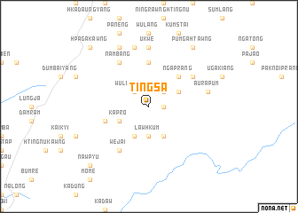
Tingsa (Kachin State, Myanmar)Tingsa is a town in the Kachin State region of Myanmar. An overview map of the region around Tingsa is displayed below.
regional and 3d topo map of Tingsa, Myanmar ::
Tingsa airports ::
The nearest airport is MYT - Myitkyina, located 66.6 km north west of Tingsa.
Other airports nearby include LSH - Lashio (206.0 km south), Nearby towns ::
N'kongkrung (1.7km east) //
Shanting (2.5km north east) //
Wulawkawng (2.5km north west) //
Law Hkum (3.7km south) //
Marau (4.1km south east) //
Kayunchet (4.1km south west) //
Wa-um (4.1km south west) //
Nahpaw (3.8km north east) //
Kapro (3.8km south west) //
Ngaprang (5.0km north east) //
Mungyi Tingnu (5.6km north) //
Tingput (5.4km west) //
Wejai (6.5km south west) //
Nambang (6.5km north west) //
Ngaprang (6.3km north east) //
Ningpwot (7.4km north) //
U-kwe (7.4km north) //
Aurapum (7.0km east) //
Sara (7.6km north) //
Mong Li (8.1km north west) //
Pum-gahtawng (9.0km north east) //
Nawpyu (10.0km south west) //
Hpagakawng (10.0km north west) //
[all distances 'as the bird flies' and approximate] 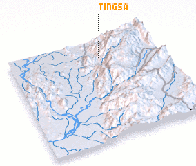 Places with similar names to Tingsa, Myanmar ::
Disclaimer :: Information on this page comes without warranty of any kind |
||
|
Where is Tingsa? Elevation and coordinates ::
Latitude (lat): 24°50'0"N Longitude (lon): 97°37'0"E
Elevation (approx.): 892m (map arrows pan, magnifying glasses zoom) |
||
|
Visiting Tingsa? Hotel/Accommodation ::
Book a hotel in Tingsa Travel Guide ::
Buy a travel guide for Myanmar rental cars ::
car rental offers GPS waypoint ::
download a GPX waypoint (PoI) of Tingsa for your GPS receiver
|
||