|
search place name
|
||
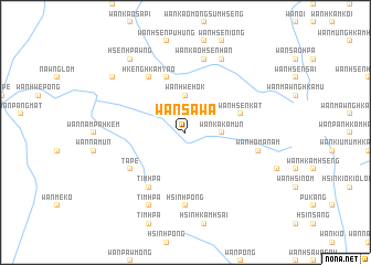
Wān Sa-wa (Shan, Myanmar)Wān Sa-wa is a town in the Shan region of Myanmar. An overview map of the region around Wān Sa-wa is displayed below.
regional and 3d topo map of Wān Sa-wa, Myanmar ::
Wān Sa-wa airports ::
The nearest airport is MOG - Mong Hsat, located 28.7 km south of Wān Sa-wa.
Other airports nearby include KET - Kengtung (75.6 km north east), THL - Tachilek Tachileik (84.4 km east), Nearby towns ::
Wān Hwè-hok (3.7km north) //
Wān Ka-ka-mün (3.5km east) //
Wān Hsenkat (5.5km east) //
Wān Kao-hkēnghkam-yao (5.8km north) //
E-u (6.6km south west) //
Timhpā (6.6km south west) //
Hkēng Hkām-yao (6.6km north west) //
Tā-pe (6.4km south west) //
Hsinhpong (7.4km south) //
Wān Kao-hsenhan (7.6km north) //
Wān Ho-manam (7.2km east) //
Wān Hsenhan (8.2km north east) //
Timhpā (8.2km south west) //
Hsen Hpawng (9.1km north west) //
Pangmā (8.9km north west) //
[all distances 'as the bird flies' and approximate] 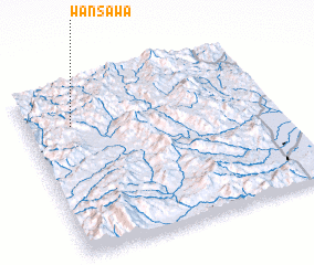 Places with similar names to Wān Sa-wa, Myanmar ::
Disclaimer :: Information on this page comes without warranty of any kind |
||
|
Where is Wān Sa-wa? Elevation and coordinates ::
Latitude (lat): 20°46'0"N Longitude (lon): 99°11'0"E
Elevation (approx.): 940m (map arrows pan, magnifying glasses zoom) |
||
|
Visiting Wān Sa-wa? Hotel/Accommodation ::
Book a hotel in Wān Sa-wa Travel Guide ::
Buy a travel guide for Myanmar rental cars ::
car rental offers GPS waypoint ::
download a GPX waypoint (PoI) of Wān Sa-wa for your GPS receiver
|
||