|
search place name
|
||
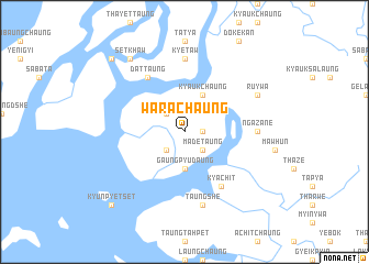
Warachaung (Rakhine, Myanmar)Warachaung is a town in the Rakhine region of Myanmar. An overview map of the region around Warachaung is displayed below.
regional and 3d topo map of Warachaung, Myanmar ::
Warachaung airports ::
The nearest airport is KYP - Kyaukpyu, located 40.3 km south west of Warachaung.
Other airports nearby include AKY - Sittwe (104.3 km north west), SNW - Thandwe (149.9 km south), CXB - Cox's Bazar Coxs Bazar (268.8 km north west), Nearby towns ::
Pyinshebyin (1.7km east) //
Madetaung (2.5km south east) //
Chindaung (2.5km north west) //
Yegaungchwein (2.5km north west) //
Kyaukhpya (2.5km south west) //
Gaungpyudaung (3.7km south) //
Kyaukchaung (4.1km north east) //
Kyachit (6.6km south east) //
Dattaung (6.6km north west) //
Pauktudaung (6.6km north west) //
Kyetaw (7.4km north) //
Ngazane (7.0km east) //
Taungshe (7.6km south) //
Ru-ywa (7.9km north east) //
Setkhaw (9.1km north west) //
Ngandaung (10.2km north west) //
Kyunpyetset (10.2km south west) //
[all distances 'as the bird flies' and approximate] 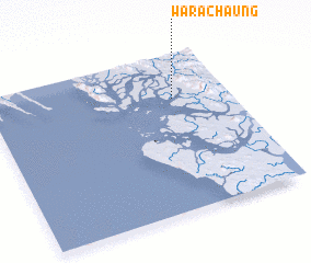 Places with similar names to Warachaung, Myanmar ::
// Warching (DE)
// Wurichongo (GH)
Disclaimer :: Information on this page comes without warranty of any kind |
||
|
Where is Warachaung? Elevation and coordinates ::
Latitude (lat): 19°43'0"N Longitude (lon): 93°46'0"E
Elevation (approx.): 18m (map arrows pan, magnifying glasses zoom) |
||
|
Visiting Warachaung? Hotel/Accommodation ::
Book a hotel in Warachaung Travel Guide ::
Buy a travel guide for Myanmar rental cars ::
car rental offers GPS waypoint ::
download a GPX waypoint (PoI) of Warachaung for your GPS receiver
|
||