|
search place name
|
||
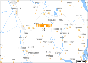
Zemathwe (Myanmar)Zemathwe is a town in Myanmar. An overview map of the region around Zemathwe is displayed below.
regional and 3d topo map of Zemathwe, Myanmar ::
Zemathwe airports ::
The nearest airport is RGN - Yangon Intl, located 140.3 km west of Zemathwe.
Nearby towns ::
Shwebaw (1.9km north) //
Inwaing (2.1km south) //
Singyon (2.6km north east) //
Kywegyan (3.1km north west) //
Sakangyi (4.6km south) //
Taingtaya (4.7km west) //
Binhlaing (5.1km north east) //
Ananbingon (5.3km east) //
Pabainggon (5.8km south) //
Nyaunggyaung (6.4km south) //
Waba (6.3km west) //
Kyaban (7.3km north west) //
Naungkyan (7.4km north) //
Gaw (7.3km west) //
Wagoktaw (8.0km south east) //
Wadaw (8.1km north) //
Pabu (8.0km north east) //
Taunggale (8.0km north east) //
Thanban (8.5km north west) //
Kama (8.4km south east) //
Duyinzeik (8.9km north) //
Thaton (8.7km west) //
Winsein (9.3km south west) //
Kyettuywethaung (10.0km south east) //
Wabodaw (10.3km north east) //
Aungsaing (10.8km south west) //
Bingyi (11.0km north east) //
[all distances 'as the bird flies' and approximate] 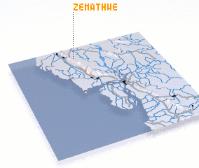 Places with similar names to Zemathwe, Myanmar :: Disclaimer :: Information on this page comes without warranty of any kind |
||
|
Where is Zemathwe? Elevation and coordinates ::
Latitude (lat): 16°54'0"N Longitude (lon): 97°27'0"E
Elevation (approx.): 5m (map arrows pan, magnifying glasses zoom) |
||
|
Visiting Zemathwe? Hotel/Accommodation ::
Book a hotel in Zemathwe Travel Guide ::
Buy a travel guide for Myanmar rental cars ::
car rental offers GPS waypoint ::
download a GPX waypoint (PoI) of Zemathwe for your GPS receiver
|
||