|
search place name
|
||
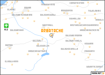
Arbatache (Blida, Algeria)Arbatache is a town in the Blida region of Algeria. An overview map of the region around Arbatache is displayed below.
regional and 3d topo map of Arbatache, Algeria ::
Arbatache airports ::
The nearest airport is ALG - Algier Houari Boumediene, located 13.8 km west of Arbatache.
Other airports nearby include BJA - Bejaja Soummam (152.7 km east), TID - Tiaret Bou Chekif (224.8 km south west), Nearby towns ::
Ouled Alia (1.5km north) //
Ouled Moussa (3.0km north) //
Saint-Paul (3.5km north) //
Khemis el Khechna (3.0km west) //
Ouled Kouadria (4.1km north west) //
Ouled Salem (4.9km south west) //
Ouled Ali (4.7km south west) //
Ouled Haddadj (7.1km north) //
Ouled Ben Norah (6.3km east) //
Haouch Aguitoune (7.3km south west) //
Oulad Issorella (7.2km south east) //
Oulad Aït Khelil (6.7km east) //
Ouled Chebacheb (7.8km north west) //
Ben Turkia (9.5km north) //
Bou Zegza (8.7km south east) //
Sidi Hallou (8.7km north east) //
Boudouaou (9.5km north east) //
El Madene Mines (9.3km south west) //
Haouch Rouiba (10.0km north west) //
[all distances 'as the bird flies' and approximate] 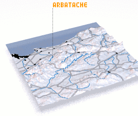 Places with similar names to Arbatache, Algeria :: Disclaimer :: Information on this page comes without warranty of any kind |
||
|
Where is Arbatache? Elevation and coordinates ::
Latitude (lat): 36°39'13"N Longitude (lon): 3°21'47"E
Elevation (approx.): 147m (map arrows pan, magnifying glasses zoom) |
||
|
Visiting Arbatache? Hotel/Accommodation ::
Book a hotel in Arbatache Travel Guide ::
Buy a travel guide for Algeria rental cars ::
car rental offers GPS waypoint ::
download a GPX waypoint (PoI) of Arbatache for your GPS receiver
|
||