|
search place name
|
||
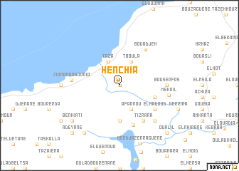
Henchia (Jijel, Algeria)Henchia is a town in the Jijel region of Algeria. An overview map of the region around Henchia is displayed below.
regional and 3d topo map of Henchia, Algeria ::
Henchia airports ::
The nearest airport is GJL - Jijel, located 32.2 km north east of Henchia.
Other airports nearby include BJA - Bejaja Soummam (43.2 km west), CZL - Constantine Mohamed Boudiaf Intl (105.3 km south east), BSK - Biskra (208.6 km south), Nearby towns ::
Arezzou (0.0km north) //
Tboula (4.0km north) //
Taza (4.0km north) //
Afarnou (4.0km south) //
Zraa el Hadjer (5.6km south) //
Oulad Ayad (4.8km south east) //
El Hadj Ameur (4.8km south east) //
Ed Damna el Kebir (6.5km south) //
Tizrara (6.3km south east) //
El Hadoud (5.8km south east) //
Bou Adjem (6.5km north east) //
Bou Serfas (5.9km east) //
Ziama Mansouria (6.1km west) //
Et Toubabcha (7.1km south east) //
Mekaïl (6.4km east) //
Beni Kati (8.1km south west) //
El Merassel (8.7km south west) //
Oualil (9.5km south east) //
Adeyane (9.5km south west) //
[all distances 'as the bird flies' and approximate] 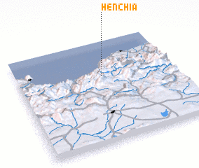 Places with similar names to Henchia, Algeria ::
Disclaimer :: Information on this page comes without warranty of any kind |
||
|
Where is Henchia? Elevation and coordinates ::
Latitude (lat): 36°40'0"N Longitude (lon): 5°33'0"E
Elevation (approx.): 328m (map arrows pan, magnifying glasses zoom) |
||
|
Visiting Henchia? Hotel/Accommodation ::
Book a hotel in Henchia Travel Guide ::
Buy a travel guide for Algeria rental cars ::
car rental offers GPS waypoint ::
download a GPX waypoint (PoI) of Henchia for your GPS receiver
|
||