|
search place name
|
||
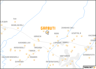
Garbuti (Abashis Raioni, Georgia)Garbuti is a town in the Abashis Raioni region of Georgia. An overview map of the region around Garbuti is displayed below.
regional and 3d topo map of Garbuti, Georgia ::
Garbuti airports ::
The nearest airport is MCX - Makhachkala Uytash, located 167.7 km north east of Garbuti.
Nearby towns ::
Mt'isdziri (0.8km north west) //
Kalaki (1.8km north west) //
P'ona (2.7km east) //
Pichkhis-Bogiri (3.6km south) //
Kapuchi (3.3km south west) //
Zemo-Bolkvi (3.6km south west) //
Gudzhareti (3.8km south east) //
Verkhvis-Mindori (4.5km south) //
Ordzhonikidze (5.4km south) //
Lapniani (5.2km south east) //
Giorget'i (6.5km south) //
Areshp'erani (5.5km south west) //
Khoshatiani (5.9km south west) //
Kevkhiani (6.7km south west) //
Bagdadi (6.7km south west) //
Kvemo-Khechili (5.6km east) //
Zemo-Khechili (6.1km east) //
Tsiplis-Tskaro (8.0km south) //
Kabali (6.8km south east) //
Karadzhala (7.1km south east) //
Ap'eni (8.5km south west) //
Zemo-Nashovari (8.2km south west) //
Kvemo-Nashovari (9.7km south west) //
Leliani (9.8km south west) //
Chabukiani (10.5km south west) //
[all distances 'as the bird flies' and approximate] 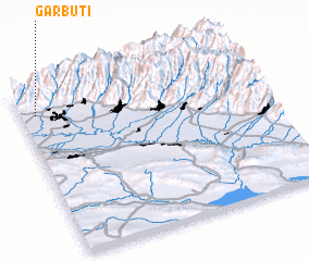 Places with similar names to Garbuti, Georgia ::
Disclaimer :: Information on this page comes without warranty of any kind |
||
|
Where is Garbuti? Elevation and coordinates ::
Latitude (lat): 41°52'19"N Longitude (lon): 46°3'56"E
Elevation (approx.): 371m (map arrows pan, magnifying glasses zoom) |
||
|
Visiting Garbuti? Hotel/Accommodation ::
Book a hotel in Garbuti Travel Guide ::
Buy a travel guide for Georgia rental cars ::
car rental offers GPS waypoint ::
download a GPX waypoint (PoI) of Garbuti for your GPS receiver
|
||