|
search place name
|
||
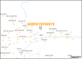
Georgiyevskoye (Abashis Raioni, Georgia)Georgiyevskoye is a town in the Abashis Raioni region of Georgia. An overview map of the region around Georgiyevskoye is displayed below.
regional and 3d topo map of Georgiyevskoye, Georgia ::
Georgiyevskoye airports ::
The nearest airport is AER - Sochi, located 122.1 km west of Georgiyevskoye.
Other airports nearby include MRV - Mineralnye Vody Mineralnyye Vody (189.4 km north east), Nearby towns ::
Chali (1.9km south west) //
Dzhampal (2.8km south west) //
Bali (3.3km south) //
Apushta (3.2km west) //
Zenobani (3.9km south east) //
Kvenobani (4.2km south east) //
Amtkel (3.8km west) //
Amzara (5.3km south) //
Amtqeli (4.6km south west) //
Panta (5.1km south west) //
Zenobani (4.1km east) //
Buduki (5.6km south) //
Khevi (5.1km south west) //
Zakharovka (5.1km south west) //
Shuamta (6.3km south west) //
Khizarukha (5.9km south east) //
Kada (5.4km west) //
Myasinovka (5.9km south east) //
Tsiplovani (7.4km south west) //
Myasinovka (6.7km east) //
Mziseuli (7.2km south west) //
Azantʼa (7.0km north west) //
[all distances 'as the bird flies' and approximate] 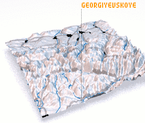 Places with similar names to Georgiyevskoye, Georgia ::
// Georgiyevskaya (RU)
// Georgiyevskaya (RU)
// Georgiyevskaya (RU)
// Georgiyevskaya (RU)
// Georgiyevskaya (RU)
// Georgiyevskaya (RU)
// Georgiyevskiye (RU)
// Georgiyevskoye (RU)
// Georgiyevskoye (RU)
// Georgiyevskoye (RU)
Disclaimer :: Information on this page comes without warranty of any kind |
||
|
Where is Georgiyevskoye? Elevation and coordinates ::
Latitude (lat): 43°3'48"N Longitude (lon): 41°21'51"E
Elevation (approx.): 589m (map arrows pan, magnifying glasses zoom) |
||
|
Visiting Georgiyevskoye? Hotel/Accommodation ::
Book a hotel in Georgiyevskoye Travel Guide ::
Buy a travel guide for Georgia rental cars ::
car rental offers GPS waypoint ::
download a GPX waypoint (PoI) of Georgiyevskoye for your GPS receiver
|
||