|
search place name
|
||
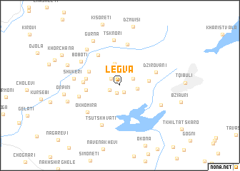
Legva (Abashis Raioni, Georgia)Legva is a town in the Abashis Raioni region of Georgia. An overview map of the region around Legva is displayed below.
regional and 3d topo map of Legva, Georgia ::
Legva airports ::
The nearest airport is MRV - Mineralnye Vody Mineralnyye Vody, located 209.9 km north of Legva.
Nearby towns ::
Dzuqnuri (1.2km south) //
Zedubani (1.2km south east) //
Khresili (1.5km north west) //
Buyeti (1.4km south west) //
Ivaneuli (1.9km north east) //
Dabadzveli (2.1km east) //
Akhaldaba (2.8km north) //
Gadmogma-Tskaltsitela (3.5km north) //
Satsire (3.4km east) //
Koreyeti (4.2km north west) //
Kʼveda Chqepi (4.0km west) //
Dzhonia (4.1km west) //
Tsikhia (4.1km west) //
Lapeti (4.3km west) //
Kit'khiji (5.4km north west) //
Prialoura (5.4km north west) //
Dzirovani (4.7km north east) //
Soch'khet'i (6.5km north) //
Okhomira (5.6km south west) //
Zeda-Chkepi (5.0km west) //
Ts'uts'khvat'i (6.6km south) //
Akhalsop'eli (5.7km south east) //
Boboti (5.9km north west) //
Tsknori (7.1km north) //
Shukeri (5.4km west) //
Antoria (6.8km north west) //
Gurna (7.7km north west) //
Koka (6.5km west) //
Nadzva (6.9km north west) //
[all distances 'as the bird flies' and approximate] 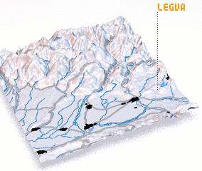 Places with similar names to Legva, Georgia ::
Disclaimer :: Information on this page comes without warranty of any kind |
||
|
Where is Legva? Elevation and coordinates ::
Latitude (lat): 42°20'25"N Longitude (lon): 42°53'52"E
Elevation (approx.): 409m (map arrows pan, magnifying glasses zoom) |
||
|
Visiting Legva? Hotel/Accommodation ::
Book a hotel in Legva Travel Guide ::
Buy a travel guide for Georgia rental cars ::
car rental offers GPS waypoint ::
download a GPX waypoint (PoI) of Legva for your GPS receiver
|
||