|
search place name
|
||
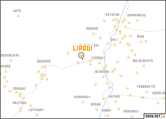
Lipodi (Abashis Raioni, Georgia)Lipodi is a town in the Abashis Raioni region of Georgia. An overview map of the region around Lipodi is displayed below.
regional and 3d topo map of Lipodi, Georgia ::
Lipodi airports ::
The nearest airport is MRV - Mineralnye Vody Mineralnyye Vody, located 241.4 km north west of Lipodi.
Nearby towns ::
Ukanakho (1.1km south west) //
Ubani (1.2km east) //
Buch'ukurt'a (1.6km south east) //
Okherkhevi (2.3km north east) //
(( Sabertse )) (2.9km north west) //
Chirdili (2.8km east) //
Barisakho (3.9km south east) //
Korsha (3.9km east) //
Achekha (5.1km south east) //
Dat'visi (5.8km south) //
Kmost'i (5.7km north east) //
Roshka (6.1km north) //
Ghelisvake (5.5km north east) //
Maghrani (5.5km south east) //
K'obulo (5.7km east) //
Gvelet'i (6.6km south east) //
Kartsaulta (5.8km east) //
Guli (6.3km north east) //
Motsmao (7.6km south east) //
Sakerpe (6.5km west) //
Chie (7.3km north east) //
Akusho (7.2km south east) //
Sach'alischala (7.5km south west) //
Sijanaani (7.3km south west) //
Betisch'rdili (9.4km south) //
Blo (9.4km north) //
Misakhe (8.7km north east) //
Gudani (8.2km north east) //
Aqneli (8.6km north east) //
[all distances 'as the bird flies' and approximate]  Places with similar names to Lipodi, Georgia ::
Disclaimer :: Information on this page comes without warranty of any kind |
||
|
Where is Lipodi? Elevation and coordinates ::
Latitude (lat): 42°29'31"N Longitude (lon): 44°52'43"E
Elevation (approx.): 1973m (map arrows pan, magnifying glasses zoom) |
||
|
Visiting Lipodi? Hotel/Accommodation ::
Book a hotel in Lipodi Travel Guide ::
Buy a travel guide for Georgia rental cars ::
car rental offers GPS waypoint ::
download a GPX waypoint (PoI) of Lipodi for your GPS receiver
|
||