|
search place name
|
||
Ojola (Georgia)Ojola is a town in Georgia. An overview map of the region around Ojola is displayed below.
regional and 3d topo map of Ojola, Georgia ::

Ojola airports ::
The nearest airport is MRV - Mineralnye Vody Mineralnyye Vody, located 205.7 km north of Ojola.
Nearby towns ::
Mandikori (2.3km south east) //
Jvarisa (2.4km south east) //
Kirovi (3.0km north) //
Khorchana (2.9km east) //
Nadzva (4.0km south east) //
Cholevi (6.0km south) //
Lekhidristavi (6.0km north east) //
Zeda-Oncheishi (6.6km north) //
Boboti (5.2km east) //
Shukeri (5.9km south east) //
Zarat'i (5.8km south west) //
K'veda Oncheishi (7.2km north) //
Chashleti (7.2km north) //
Kursebi (7.3km south) //
Kudoti (5.8km south west) //
Mechkheri (6.1km south west) //
Sach'kheuri (7.1km north east) //
Orpiri (7.2km south east) //
Antoria (5.8km east) //
Naboslevi (7.9km south) //
Sormoni (7.8km south west) //
Lapeti (7.0km south east) //
Tsikhia (6.9km south east) //
Dzhonia (6.9km south east) //
Koreyeti (6.7km south east) //
Gurna (6.7km east) //
Koka (8.4km south east) //
Rioni (7.7km south west) //
Namokhvani (7.3km north west) //
[all distances 'as the bird flies' and approximate] 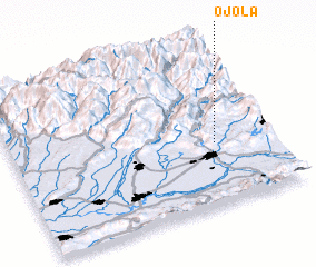 Places with similar names to Ojola, Georgia ::
Disclaimer :: Information on this page comes without warranty of any kind |
||
|
Where is Ojola? Elevation and coordinates ::
Latitude (lat): 42°23'11"N Longitude (lon): 42°46'53"E
Elevation (approx.): 527m (map arrows pan, magnifying glasses zoom) |
||
|
Visiting Ojola? Hotel/Accommodation ::
Book a hotel in Ojola Travel Guide ::
Buy a travel guide for Georgia rental cars ::
car rental offers GPS waypoint ::
download a GPX waypoint (PoI) of Ojola for your GPS receiver
|
||