|
search place name
|
||
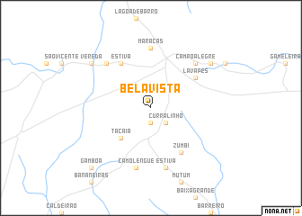
Bela Vista (Bahia, Brazil)Bela Vista is a town in the Bahia region of Brazil. An overview map of the region around Bela Vista is displayed below.
regional and 3d topo map of Bela Vista, Brazil ::
Bela Vista airports ::
The nearest airport is IOS - Ilheus, located 211.2 km south east of Bela Vista.
Nearby towns ::
Bom Jardim (1.9km south) //
Curralinho (2.6km south east) //
Tacaia (5.2km south west) //
Estiva (6.6km north west) //
Zumbi (6.6km south east) //
Lava-Pés (6.6km north east) //
Maracás (7.4km north) //
Camolengue (7.6km south) //
Estiva (7.6km south) //
Santa Maria (7.8km north west) //
Campo Alegre (7.8km north east) //
Vereda (9.1km north west) //
Barra Funda (9.1km north east) //
Gamboa (10.3km south west) //
[all distances 'as the bird flies' and approximate] 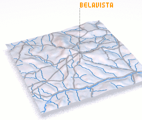 Places with similar names to Bela Vista, Brazil ::
// Belfast (JM)
// Bellavista (PE)
// Belle Vista (US)
// Bluff City (US)
// Blue Vista (US)
// Belfast (US)
// Bella Vista (US)
// Bella Vista (US)
// Bluff City (US)
// Belfast (US)
Disclaimer :: Information on this page comes without warranty of any kind |
||
|
Where is Bela Vista? Elevation and coordinates ::
Latitude (lat): 13°30'0"S Longitude (lon): 40°27'0"W
Elevation (approx.): 934m (map arrows pan, magnifying glasses zoom) |
||
|
Visiting Bela Vista? Hotel/Accommodation ::
Book a hotel in Bela Vista Travel Guide ::
Buy a travel guide for Brazil rental cars ::
car rental offers GPS waypoint ::
download a GPX waypoint (PoI) of Bela Vista for your GPS receiver
|
||