|
search place name
|
||
Canafístula (Rio Grande do Norte, Brazil)Canafístula is a town in the Rio Grande do Norte region of Brazil. An overview map of the region around Canafístula is displayed below.
regional and 3d topo map of Canafístula, Brazil ::

Canafístula airports ::
The nearest airport is NAT - Natal Augusto Severo, located 154.1 km south east of Canafístula.
Other airports nearby include CPV - Campina Grande Presidente Joao Suassuna (220.5 km south), JPA - Joao Pessoa Presidente Castro Pinto (262.5 km south east), FOR - Fortaleza Pinto Martins Intl (284.0 km north west), Nearby towns ::
Santa Rita (2.5km south) //
Mulungu (3.4km north) //
Leonardo (4.0km west) //
Capim Queimado (5.3km south west) //
Agua Nova (5.5km north) //
Pedra de Fogo (6.0km east) //
Campos Novos (6.3km south west) //
São Sebastião (6.5km south) //
Riacho Grande (7.1km north west) //
Bela Vista (8.4km north east) //
Sítio Barro Vermelho (8.6km south) //
Caieiras de São Pedro (9.9km south west) //
Barra do Bode (10.1km north west) //
[all distances 'as the bird flies' and approximate] 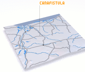 Places with similar names to Canafístula, Brazil ::
// Cañafístulo (PA)
// Cañafístola (CO)
// Cañafístola (CO)
// Cañafístula (CO)
// Cañafístula (CR)
// Cañafístula (CR)
// Cañafístula (SV)
// Cañafístula (SV)
// Canafistola (VE)
// Cañafistola (VE)
Disclaimer :: Information on this page comes without warranty of any kind |
||
|
Where is Canafístula? Elevation and coordinates ::
Latitude (lat): 5°22'51"S Longitude (lon): 36°32'1"W
Elevation (approx.): 32m (map arrows pan, magnifying glasses zoom) |
||
|
Visiting Canafístula? Hotel/Accommodation ::
Book a hotel in Canafístula Travel Guide ::
Buy a travel guide for Brazil rental cars ::
car rental offers GPS waypoint ::
download a GPX waypoint (PoI) of Canafístula for your GPS receiver
|
||