|
search place name
|
||
Curralinho (Amazonas, Brazil)Curralinho is a town in the Amazonas region of Brazil. An overview map of the region around Curralinho is displayed below.
regional and 3d topo map of Curralinho, Brazil ::
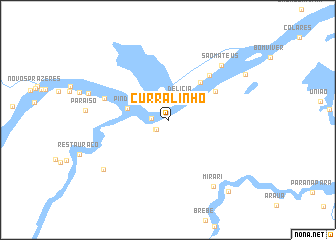
Nearby towns ::
Bela Vista (1.2km north) //
Santo Antônio do Atininga (1.7km south west) //
Recreio Atininga (1.8km south west) //
Pinduri (1.8km west) //
Delícia (2.8km north east) //
Santo Antônio (4.0km north east) //
Pinduri (4.7km west) //
Primavera (5.5km north east) //
Jenipapo (6.1km north east) //
São Raimundo (6.8km north east) //
Providência (7.5km west) //
São Mateus (8.5km north east) //
Mirari (9.0km south east) //
Campo Alegre (9.0km south west) //
Porto Seguro (10.0km north east) //
Terra Preta (10.5km south east) //
[all distances 'as the bird flies' and approximate] 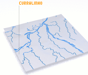 Places with similar names to Curralinho, Brazil ::
// Krela N'hai (VN)
// Curralinho (BR)
// Curralinho (BR)
// Curralinho (BR)
// Curralinha (BR)
// Curralinho (BR)
// Curralinho (BR)
// Curralinho (BR)
// Curralinho (BR)
// Curralinho (BR)
Disclaimer :: Information on this page comes without warranty of any kind |
||
|
Where is Curralinho? Elevation and coordinates ::
Latitude (lat): 5°36'2"S Longitude (lon): 60°58'7"W
Elevation (approx.): 41m (map arrows pan, magnifying glasses zoom) |
||
|
Visiting Curralinho? Hotel/Accommodation ::
Book a hotel in Curralinho Travel Guide ::
Buy a travel guide for Brazil rental cars ::
car rental offers GPS waypoint ::
download a GPX waypoint (PoI) of Curralinho for your GPS receiver
|
||