|
search place name
|
||
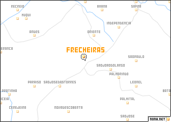
Frecheiras (Espírito Santo, Brazil)Frecheiras is a town in the Espírito Santo region of Brazil. An overview map of the region around Frecheiras is displayed below.
regional and 3d topo map of Frecheiras, Brazil ::
Frecheiras airports ::
The nearest airport is CAW - Campos Bartolomeu Lisandro, located 74.6 km south of Frecheiras.
Other airports nearby include VIX - Vitoria Goiabeiras (126.9 km north east), IPN - Ipatinga Usiminas (220.2 km north west), SDU - Rio De Janeiro Santos Dumont (291.6 km south west), Nearby towns ::
Oriente (5.8km north) //
São João do Largo (5.5km east) //
São José das Tôrres (7.6km south west) //
Palmorindo (7.8km south east) //
Independência (10.1km north east) //
[all distances 'as the bird flies' and approximate] 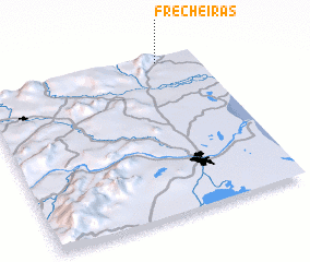 Places with similar names to Frecheiras, Brazil ::
// Ferry Shores (US)
// Verchères (CA)
// Frecheiras (BR)
// Frecheiras (BR)
// Frecheiras (BR)
// Frecheiras (BR)
// Frecheiras (BR)
// Frecheiras (BR)
// Frecheiras (BR)
// Verchères (FR)
Disclaimer :: Information on this page comes without warranty of any kind |
||
|
Where is Frecheiras? Elevation and coordinates ::
Latitude (lat): 21°2'0"S Longitude (lon): 41°11'0"W
Elevation (approx.): 74m (map arrows pan, magnifying glasses zoom) |
||
|
Visiting Frecheiras? Hotel/Accommodation ::
Book a hotel in Frecheiras Travel Guide ::
Buy a travel guide for Brazil rental cars ::
car rental offers GPS waypoint ::
download a GPX waypoint (PoI) of Frecheiras for your GPS receiver
|
||