|
search place name
|
||
Para-Mirim (Maranhão, Brazil)Para-Mirim is a town in the Maranhão region of Brazil. An overview map of the region around Para-Mirim is displayed below.
regional and 3d topo map of Para-Mirim, Brazil ::

Para-Mirim airports ::
The nearest airport is THE - Teresina Senador Petronio Portella, located 119.9 km south of Para-Mirim.
Other airports nearby include SLZ - Sao Luis Marechal Cunha Machado Intl (209.8 km north west), Nearby towns ::
Criminoso (2.2km east) //
Bom Jesus II (2.7km north west) //
Vargem (2.8km north west) //
Caxingó (3.4km west) //
Buenos Aires (3.5km north east) //
Brejinho (3.6km west) //
Bom Jesus I (3.8km north) //
Gamela (3.8km east) //
Saquinho (3.9km east) //
São Francisco (3.9km east) //
São Domingos (4.3km north west) //
Saquinho (4.9km north west) //
Sobrado (5.6km west) //
Alazão dos Cardosos (6.0km east) //
Bebida Nova (6.1km north) //
João de Sousa (6.3km north west) //
Fazenda Nova (6.3km north west) //
Salinas (6.7km east) //
Barriguda (7.0km north) //
Morros (7.1km north east) //
Esquia (7.1km west) //
Baixa do Capim (7.3km north east) //
Baixão (7.4km west) //
Buriti (7.6km north) //
Portela (7.9km east) //
Campo Comprido (8.6km east) //
Sucuriju (8.7km west) //
Matinha (8.9km north west) //
Cacimba II (9.2km west) //
[all distances 'as the bird flies' and approximate] 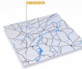 Places with similar names to Para-Mirim, Brazil ::
Disclaimer :: Information on this page comes without warranty of any kind |
||
|
Where is Para-Mirim? Elevation and coordinates ::
Latitude (lat): 3°59'5"S Longitude (lon): 42°57'35"W
Elevation (approx.): 51m (map arrows pan, magnifying glasses zoom) |
||
|
Visiting Para-Mirim? Hotel/Accommodation ::
Book a hotel in Para-Mirim Travel Guide ::
Buy a travel guide for Brazil rental cars ::
car rental offers GPS waypoint ::
download a GPX waypoint (PoI) of Para-Mirim for your GPS receiver
|
||