|
search place name
|
||
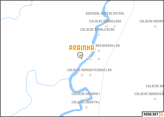
Prainha (Amazonas, Brazil)Prainha is a town in the Amazonas region of Brazil. An overview map of the region around Prainha is displayed below.
regional and 3d topo map of Prainha, Brazil ::
Prainha airports ::
The nearest airport is RBR - Rio Branco Presidente Medici, located 74.9 km south west of Prainha.
Other airports nearby include CIJ - Cobija Heroes Del Acre (236.9 km south west), Nearby towns ::
Colocação Redenção Nova (1.8km east) //
Colocação China (1.8km east) //
Colocação Arati (3.7km east) //
Colocação Pelotas (3.7km south) //
Colocação Barro Vermelho (4.1km north east) //
Colocação Redenção Velha (4.1km south east) //
Colocação Bom Jardim (6.7km north east) //
Colocação Salvação (6.7km north east) //
Colocação São José (9.2km north east) //
Colocação Porto Rico (9.2km north east) //
Colocação Porto Alegre (10.4km north east) //
Seringal Santa Filomena (10.4km north east) //
[all distances 'as the bird flies' and approximate] 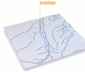 Places with similar names to Prainha, Brazil ::
Disclaimer :: Information on this page comes without warranty of any kind |
||
|
Where is Prainha? Elevation and coordinates ::
Latitude (lat): 9°19'0"S Longitude (lon): 67°30'0"W
Elevation (approx.): 159m (map arrows pan, magnifying glasses zoom) |
||
|
Visiting Prainha? Hotel/Accommodation ::
Book a hotel in Prainha Travel Guide ::
Buy a travel guide for Brazil rental cars ::
car rental offers GPS waypoint ::
download a GPX waypoint (PoI) of Prainha for your GPS receiver
|
||