|
search place name
|
||
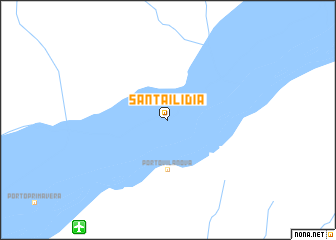
Santa Ilídia (Mato Grosso do Sul, Brazil)Santa Ilídia is a town in the Mato Grosso do Sul region of Brazil. An overview map of the region around Santa Ilídia is displayed below.
regional and 3d topo map of Santa Ilídia, Brazil ::
Santa Ilídia airports ::
The nearest airport is MGF - Regional De Maringa Silvio Name Junior, located 147.2 km south east of Santa Ilídia.
Other airports nearby include PPB - President Prudente Presidente Prudente (152.7 km east), LDB - Londrina (206.6 km south east), CGR - Campo Grande (284.5 km north west), Nearby towns ::
Pôrto Maria (5.6km south) //
Pôrto Vila Nova (5.6km south) //
[all distances 'as the bird flies' and approximate] 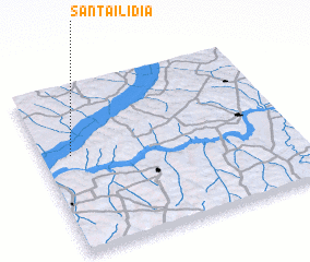 Places with similar names to Santa Ilídia, Brazil ::
// Santa Alaide (BR)
// Santa Alda (BR)
// Santa Lídia (BR)
// Søndeled (NO)
// Sănduliţa (RO)
// Santa Lidia (PY)
// Sainte-Aulde (FR)
// Saint-Illide (FR)
// Sintaluta (CA)
// Sandolot (PH)
Disclaimer :: Information on this page comes without warranty of any kind |
||
|
Where is Santa Ilídia? Elevation and coordinates ::
Latitude (lat): 22°25'0"S Longitude (lon): 52°53'0"W
Elevation (approx.): 252m (map arrows pan, magnifying glasses zoom) |
||
|
Visiting Santa Ilídia? Hotel/Accommodation ::
Book a hotel in Santa Ilídia Travel Guide ::
Buy a travel guide for Brazil rental cars ::
car rental offers GPS waypoint ::
download a GPX waypoint (PoI) of Santa Ilídia for your GPS receiver
|
||