|
search place name
|
||
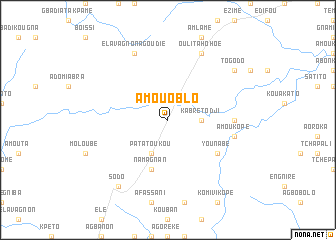
Amou Oblo (Togo)Amou Oblo is a town in Togo. An overview map of the region around Amou Oblo is displayed below.
regional and 3d topo map of Amou Oblo, Togo ::
Amou Oblo airports ::
The nearest airport is LFW - Lome Gnassingbe Eyadema Intl, located 141.3 km south of Amou Oblo.
Other airports nearby include COO - Cotonou Cadjehoun (202.5 km south east), ACC - Accra Kotoka Intl (227.5 km south west), Nearby towns ::
Kabré Todji (3.7km east) //
Patatoukou (4.1km south west) //
Namagnan (5.9km south) //
Younabé (6.6km south east) //
Amoukopé (7.4km east) //
Amoukopé (7.6km east) //
Oulita Hohoé (8.3km north east) //
Agadji (8.3km north east) //
Elavagnon Agoudié (8.3km north west) //
Togodo (9.2km north east) //
Sodo (9.2km south west) //
[all distances 'as the bird flies' and approximate] 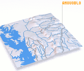 Places with similar names to Amou Oblo, Togo ::
Disclaimer :: Information on this page comes without warranty of any kind |
||
|
Where is Amou Oblo? Elevation and coordinates ::
Latitude (lat): 7°23'0"N Longitude (lon): 0°52'0"W
Elevation (approx.): 297m (map arrows pan, magnifying glasses zoom) |
||
|
Visiting Amou Oblo? Hotel/Accommodation ::
Book a hotel in Amou Oblo Travel Guide ::
Buy a travel guide for Togo rental cars ::
car rental offers GPS waypoint ::
download a GPX waypoint (PoI) of Amou Oblo for your GPS receiver
|
||