|
search place name
|
||
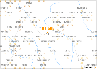
Atigbé (Togo)Atigbé is a town in Togo. An overview map of the region around Atigbé is displayed below.
regional and 3d topo map of Atigbé, Togo ::
Atigbé airports ::
The nearest airport is LFW - Lome Gnassingbe Eyadema Intl, located 96.0 km south east of Atigbé.
Other airports nearby include ACC - Accra Kotoka Intl (166.3 km south west), COO - Cotonou Cadjehoun (193.6 km east), Nearby towns ::
Klonou (1.8km west) //
Agou-Gare (2.6km north east) //
Assahun Fiagbé (3.7km south) //
Tafié (3.7km east) //
Dzogbépimé (4.1km south east) //
Tomé (4.1km south west) //
Agou Tomegbé (4.1km north east) //
Akoumahou (4.1km north east) //
Apégamé (4.1km north east) //
Bouita (5.2km north east) //
Dougadji (5.2km north east) //
Gadjawoukpé (5.5km east) //
Etoé (5.8km east) //
Dalavé (5.8km east) //
Liatonou (5.9km north) //
Agbéssia (6.7km north west) //
Agou Gadzépé (6.7km north east) //
Ahoundjo (6.6km north west) //
Djigbé (6.6km north west) //
Agbladomé (6.6km north east) //
Atchavé (7.4km west) //
Sodokékopé (7.6km south) //
Niamessi (7.6km south) //
Agnibé (7.6km south) //
Bolomegblé (7.6km west) //
Gadjagan (7.6km east) //
Tové (7.8km north west) //
Adamé (8.3km south west) //
Agoukpoéta (8.2km south west) //
[all distances 'as the bird flies' and approximate] 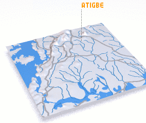 Places with similar names to Atigbé, Togo ::
Disclaimer :: Information on this page comes without warranty of any kind |
||
|
Where is Atigbé? Elevation and coordinates ::
Latitude (lat): 6°50'0"N Longitude (lon): 0°42'0"W
Elevation (approx.): 197m (map arrows pan, magnifying glasses zoom) |
||
|
Visiting Atigbé? Hotel/Accommodation ::
Book a hotel in Atigbé Travel Guide ::
Buy a travel guide for Togo rental cars ::
car rental offers GPS waypoint ::
download a GPX waypoint (PoI) of Atigbé for your GPS receiver
|
||