|
search place name
|
||
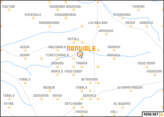
Nandialé (Togo)Nandialé is a town in Togo. An overview map of the region around Nandialé is displayed below.
regional and 3d topo map of Nandialé, Togo ::
Nandialé airports ::
The nearest airport is LRL - Niatougou Niamtougou International, located 61.5 km north east of Nandialé.
Other airports nearby include TML - Tamale (160.8 km west), Nearby towns ::
Namoré (1.8km west) //
Nanjéré (1.9km south) //
Tabara (1.9km south) //
Namanjo (2.6km south west) //
Bouélé (2.6km north west) //
Bapuré (3.1km north east) //
Borbogou (3.7km north) //
Koudyopongpong (4.1km south east) //
Bitiakpa (4.1km north east) //
Patiéli (4.1km north west) //
Koudyobon (4.1km south west) //
Tchotchopola (5.5km west) //
Insadou (5.8km west) //
Boro (5.8km west) //
Poutamélé (5.8km west) //
Bitankpan (5.9km south) //
Bapélé (6.6km south west) //
Bélémélé (6.7km south east) //
Nankoul (7.3km east) //
Inkoukoumamné (7.4km north) //
Tabalé (7.4km south) //
Nanaéni (7.5km east) //
Bissibi (7.6km south) //
Manniédo (7.8km north east) //
Lidyobilbou (8.3km north east) //
Niagbangbou (10.4km north west) //
Béoaja (10.4km south west) //
[all distances 'as the bird flies' and approximate]  Places with similar names to Nandialé, Togo ::
Disclaimer :: Information on this page comes without warranty of any kind |
||
|
Where is Nandialé? Elevation and coordinates ::
Latitude (lat): 9°30'0"N Longitude (lon): 0°36'0"W
Elevation (approx.): 172m (map arrows pan, magnifying glasses zoom) |
||
|
Visiting Nandialé? Hotel/Accommodation ::
Book a hotel in Nandialé Travel Guide ::
Buy a travel guide for Togo rental cars ::
car rental offers GPS waypoint ::
download a GPX waypoint (PoI) of Nandialé for your GPS receiver
|
||