|
search place name
|
||
Tessiam (Togo)Tessiam is a town in Togo. An overview map of the region around Tessiam is displayed below.
regional and 3d topo map of Tessiam, Togo ::

Tessiam airports ::
The nearest airport is LFW - Lome Gnassingbe Eyadema Intl, located 183.4 km south of Tessiam.
Other airports nearby include COO - Cotonou Cadjehoun (242.1 km south east), TML - Tamale (264.2 km north west), Nearby towns ::
Dafé (0.0km north) //
Yadé (1.8km west) //
Bloumfou (2.6km north east) //
Kouaro (2.6km south east) //
Modjaï (2.6km south east) //
Alavanio (4.1km south east) //
Kalakongon (5.2km south east) //
Brékoukou (5.5km east) //
Batéo (5.5km east) //
Anigouaménio (6.7km south east) //
Boinkéré (6.7km south east) //
Dakpa (6.7km south east) //
Niélé (9.2km south east) //
Venkounia (9.2km south east) //
[all distances 'as the bird flies' and approximate] 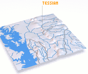 Places with similar names to Tessiam, Togo ::
Disclaimer :: Information on this page comes without warranty of any kind |
||
|
Where is Tessiam? Elevation and coordinates ::
Latitude (lat): 7°43'0"N Longitude (lon): 0°40'0"W
Elevation (approx.): 308m (map arrows pan, magnifying glasses zoom) |
||
|
Visiting Tessiam? Hotel/Accommodation ::
Book a hotel in Tessiam Travel Guide ::
Buy a travel guide for Togo rental cars ::
car rental offers GPS waypoint ::
download a GPX waypoint (PoI) of Tessiam for your GPS receiver
|
||