|
search place name
|
||
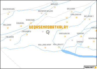
De Qāsem Robāţ Kalay (Kandahār, Afghanistan)De Qāsem Robāţ Kalay is a town in the Kandahār region of Afghanistan. An overview map of the region around De Qāsem Robāţ Kalay is displayed below.
regional and 3d topo map of De Qāsem Robāţ Kalay, Afghanistan ::
De Qāsem Robāţ Kalay airports ::
The nearest airport is KDH - Kandahar, located 36.8 km east of De Qāsem Robāţ Kalay.
Other airports nearby include UET - Quetta (195.8 km south east), Nearby towns ::
Rēgay (2.3km north west) //
Speyrawān (3.7km north west) //
Mollā Ashraf (5.1km south) //
Khenjakak (5.4km east) //
Mollā Dūst (6.0km south east) //
Bāzār-e Panjvā'i (8.0km north) //
Sīāh Chūb (7.4km north west) //
Zangābād (7.2km west) //
Şalavāt (7.8km north east) //
Bayānzi (8.7km north) //
Mohājerīn (8.8km north east) //
Şāleḩān (11.7km north east) //
[all distances 'as the bird flies' and approximate]  Places with similar names to De Qāsem Robāţ Kalay, Afghanistan :: Disclaimer :: Information on this page comes without warranty of any kind |
||
|
Where is De Qāsem Robāţ Kalay? Elevation and coordinates ::
Latitude (lat): 31°28'34"N Longitude (lon): 65°27'44"E
Elevation (approx.): 933m (map arrows pan, magnifying glasses zoom) |
||
|
Visiting De Qāsem Robāţ Kalay? Hotel/Accommodation ::
Book a hotel in De Qāsem Robāţ Kalay Travel Guide ::
Buy a travel guide for Afghanistan rental cars ::
car rental offers GPS waypoint ::
download a GPX waypoint (PoI) of De Qāsem Robāţ Kalay for your GPS receiver
|
||