|
search place name
|
||
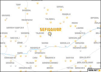
Sefīd Dīvār (Vardak, Afghanistan)Sefīd Dīvār is a town in the Vardak region of Afghanistan. An overview map of the region around Sefīd Dīvār is displayed below.
regional and 3d topo map of Sefīd Dīvār, Afghanistan ::
Sefīd Dīvār airports ::
The nearest airport is KBL - Kabul Intl, located 122.5 km east of Sefīd Dīvār.
Nearby towns ::
Tājekān (3.1km west) //
Shīnah (4.0km south) //
‘Aţā-ye Pol-e Afghānān (4.0km south) //
Tālā Qowl (5.1km north) //
Rashak (5.7km north east) //
Gardan Borīdeh (6.3km south west) //
Sar-e ‘Olūm (5.9km south east) //
Eskah (6.7km north east) //
Chūmī (7.6km south) //
Dīvāl Qowl (7.6km south) //
Nāvor Sūp (7.2km south west) //
Qarkh-e Bālā (7.1km north east) //
Spī Sangak (8.0km south) //
Dowlat Gharībī (8.4km north) //
Now Qalā (8.5km north east) //
Bābah Khān (8.3km south west) //
Nāvor Sabz (8.5km north west) //
Shīw Qowl (10.9km north west) //
[all distances 'as the bird flies' and approximate] 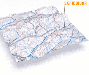 Places with similar names to Sefīd Dīvār, Afghanistan ::
// Sefīd Dīvār (AF)
Disclaimer :: Information on this page comes without warranty of any kind |
||
|
Where is Sefīd Dīvār? Elevation and coordinates ::
Latitude (lat): 34°28'0"N Longitude (lon): 67°53'0"E
Elevation (approx.): 2848m (map arrows pan, magnifying glasses zoom) |
||
|
Visiting Sefīd Dīvār? Hotel/Accommodation ::
Book a hotel in Sefīd Dīvār Travel Guide ::
Buy a travel guide for Afghanistan rental cars ::
car rental offers GPS waypoint ::
download a GPX waypoint (PoI) of Sefīd Dīvār for your GPS receiver
|
||