|
search place name
|
||
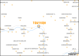
Towy Kah (Vardak, Afghanistan)Towy Kah is a town in the Vardak region of Afghanistan. An overview map of the region around Towy Kah is displayed below.
regional and 3d topo map of Towy Kah, Afghanistan ::
Towy Kah airports ::
The nearest airport is KBL - Kabul Intl, located 76.5 km north east of Towy Kah.
Nearby towns ::
Peyvand (2.4km south east) //
Khar Khēl (2.4km north east) //
Darreh-ye Jolgeh (3.1km west) //
Gowdā (3.7km south) //
Karam ‘Alī (4.0km south) //
Nāzok Kheyl (5.0km west) //
Āzād Kheyl (5.8km south) //
Baldarghanak (5.8km north) //
Chak (6.3km south east) //
Kalākh (6.1km west) //
Gwalay (6.4km west) //
‘Emārat Khēl (7.6km south) //
‘Omarzī (7.6km south) //
Shāhī Kheyl (7.2km north east) //
Kondor Khēyl (7.2km north east) //
Kārīz (7.2km south west) //
Sīāh Chaghar (7.2km north east) //
[all distances 'as the bird flies' and approximate] 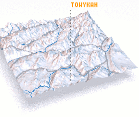 Places with similar names to Towy Kah, Afghanistan ::
Disclaimer :: Information on this page comes without warranty of any kind |
||
|
Where is Towy Kah? Elevation and coordinates ::
Latitude (lat): 34°14'0"N Longitude (lon): 68°29'0"E
Elevation (approx.): 2410m (map arrows pan, magnifying glasses zoom) |
||
|
Visiting Towy Kah? Hotel/Accommodation ::
Book a hotel in Towy Kah Travel Guide ::
Buy a travel guide for Afghanistan rental cars ::
car rental offers GPS waypoint ::
download a GPX waypoint (PoI) of Towy Kah for your GPS receiver
|
||