|
search place name
|
||
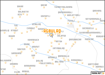
Ağbulaq (Xocavǝnd, Azerbaijan)Ağbulaq is a town in the Xocavǝnd region of Azerbaijan. An overview map of the region around Ağbulaq is displayed below.
regional and 3d topo map of Ağbulaq, Azerbaijan ::
Ağbulaq airports ::
The nearest airport is TBZ - Tabriz Intl, located 174.1 km south west of Ağbulaq.
Nearby towns ::
Xırmancıq (1.4km south east) //
Axullu (1.5km north east) //
Edilli (1.4km north west) //
Bulutan (2.0km south) //
Chiman (2.0km north east) //
Cuvarlı (2.4km north east) //
Melikcanlı (3.2km south) //
Xǝlafşǝ (2.5km east) //
Arysh (2.9km south east) //
Düdükçü (3.5km north west) //
Qaradağlı (4.7km south) //
Xatınbulaq (5.1km south) //
Qoçǝhmǝdli (4.3km south east) //
Qoçbǝyli (5.4km south) //
Güneşli (6.1km south) //
Mollaveli (6.0km south east) //
Üçbulaq (5.8km north west) //
Kemrakuch (5.5km west) //
Govşatlı (7.0km north) //
Hadrut (6.2km south west) //
Zǝrgǝr (7.2km north) //
Fioletovka (6.6km north east) //
Yal Pirǝhmadli (6.2km south east) //
Sardarli (6.2km east) //
Doshulu (7.9km south) //
Dağdöşü (7.1km south west) //
Ciraquz (6.5km west) //
Qarğabazar (6.5km east) //
Füzuli (7.2km north east) //
[all distances 'as the bird flies' and approximate]  Places with similar names to Ağbulaq, Azerbaijan ::
Disclaimer :: Information on this page comes without warranty of any kind |
||
|
Where is Ağbulaq? Elevation and coordinates ::
Latitude (lat): 39°33'17"N Longitude (lon): 47°4'59"E
Elevation (approx.): 701m (map arrows pan, magnifying glasses zoom) |
||
|
Visiting Ağbulaq? Hotel/Accommodation ::
Book a hotel in Ağbulaq Travel Guide ::
Buy a travel guide for Azerbaijan rental cars ::
car rental offers GPS waypoint ::
download a GPX waypoint (PoI) of Ağbulaq for your GPS receiver
|
||