|
search place name
|
||
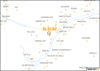
Alolar (Kǝlbǝcǝr, Azerbaijan)Alolar is a town in the Kǝlbǝcǝr region of Azerbaijan. An overview map of the region around Alolar is displayed below.
regional and 3d topo map of Alolar, Azerbaijan ::
Alolar airports ::
The nearest airport is TBZ - Tabriz Intl, located 218.6 km south of Alolar.
Nearby towns ::
Armudlu (1.3km south) //
Keşdǝk (2.8km south) //
Otaqlı (3.0km north) //
Kǝlbǝcǝr (2.5km north east) //
Mǝmmǝduşağı (2.9km south east) //
Oktyabrkǝnd (3.7km north) //
Kylychly (3.9km north west) //
Aşağı Ayrım (4.0km north east) //
Amirallar (4.1km south west) //
Derekyshlak (3.9km north east) //
Allykend (4.6km north) //
Hǝsǝnlǝr (3.9km west) //
Tatlar (4.4km south east) //
Şaplar (3.9km east) //
Gasanlar (5.0km north west) //
Sınıqkilsǝ (5.3km north) //
Yuxarı Ayrım (5.8km north) //
Ferkhani (4.5km east) //
Çaykǝnd (5.5km north east) //
Şǝnlik (7.0km south) //
Yellicǝ (5.4km west) //
Orta Qaraçanlı (7.0km south) //
Mishni (6.8km north east) //
Hopurlu (7.0km south west) //
Birinci Milli (6.0km east) //
Ashagy Karashanly (7.4km south east) //
Sarygyuney (7.6km north east) //
Xolǝzǝy Alxaslı (8.9km south) //
Kilisekend (9.1km north east) //
[all distances 'as the bird flies' and approximate] 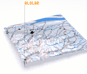 Places with similar names to Alolar, Azerbaijan ::
// Alaléri (SN)
Disclaimer :: Information on this page comes without warranty of any kind |
||
|
Where is Alolar? Elevation and coordinates ::
Latitude (lat): 40°5'42"N Longitude (lon): 46°0'50"E
Elevation (approx.): 1766m (map arrows pan, magnifying glasses zoom) |
||
|
Visiting Alolar? Hotel/Accommodation ::
Book a hotel in Alolar Travel Guide ::
Buy a travel guide for Azerbaijan rental cars ::
car rental offers GPS waypoint ::
download a GPX waypoint (PoI) of Alolar for your GPS receiver
|
||