|
search place name
|
||
Avun (Yardımlı, Azerbaijan)Avun is a town in the Yardımlı region of Azerbaijan. An overview map of the region around Avun is displayed below.
regional and 3d topo map of Avun, Azerbaijan ::

Avun airports ::
The nearest airport is TBZ - Tabriz Intl, located 191.6 km south west of Avun.
Other airports nearby include RAS - Rasht (207.7 km south east), BAK - Baku Heydar Aliyev (237.6 km north east), Nearby towns ::
Qaragaya (1.6km north west) //
Nisakyala (2.3km north west) //
Osnakǝran (3.2km north) //
Hamarkǝnd (3.0km east) //
Asadabad (3.7km north) //
Zangyaran (2.9km east) //
Urakǝran (3.7km north west) //
Şıxhüseynli (4.1km south) //
Şilǝvǝngǝ (4.5km north) //
Anzov (3.8km north east) //
Bozayran (5.1km north) //
Gavran (5.2km north) //
Solgart (4.3km east) //
Allar (5.8km south) //
Xanǝgah (4.8km east) //
Abbasabad (5.2km north east) //
Peştǝsar (5.0km west) //
Avur (5.7km north west) //
Burzunbül (5.9km north east) //
Dağ Üzü (5.7km west) //
Çay Üzü (6.1km north west) //
Ostayır (7.5km north) //
Ökü (7.0km north west) //
Bilʼna (6.1km east) //
Yardımlı (7.9km north) //
Kabakhdibi (8.0km north) //
Sırıq (8.0km north) //
Daşkǝnd (8.3km north) //
Kër”yadi (8.3km north east) //
[all distances 'as the bird flies' and approximate] 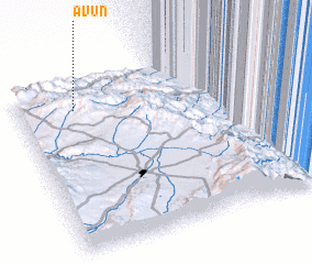 Places with similar names to Avun, Azerbaijan ::
Disclaimer :: Information on this page comes without warranty of any kind |
||
|
Where is Avun? Elevation and coordinates ::
Latitude (lat): 38°51'0"N Longitude (lon): 48°14'0"E
Elevation (approx.): 1169m (map arrows pan, magnifying glasses zoom) |
||
|
Visiting Avun? Hotel/Accommodation ::
Book a hotel in Avun Travel Guide ::
Buy a travel guide for Azerbaijan rental cars ::
car rental offers GPS waypoint ::
download a GPX waypoint (PoI) of Avun for your GPS receiver
|
||