|
search place name
|
||
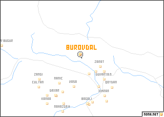
Burovdal (İsmayıllı, Azerbaijan)Burovdal is a town in the İsmayıllı region of Azerbaijan. An overview map of the region around Burovdal is displayed below.
regional and 3d topo map of Burovdal, Azerbaijan ::
Burovdal airports ::
The nearest airport is BAK - Baku Heydar Aliyev, located 151.1 km east of Burovdal.
Other airports nearby include MCX - Makhachkala Uytash (216.5 km north), Nearby towns ::
Varna (3.7km south) //
Gendǝrǝ (3.8km south east) //
Zarat (3.6km south east) //
Çandaxar (4.8km south east) //
Vaşa (6.6km south) //
Duvaryan (6.1km south east) //
Hǝrtǝsov (7.0km south east) //
Nanıc (6.8km south west) //
Müdri (8.4km south west) //
Qoydan (8.4km south east) //
Ximran (9.5km south east) //
Müdrǝsǝ (9.7km south west) //
Daxar (9.6km south west) //
Mulux (10.4km south west) //
[all distances 'as the bird flies' and approximate] 
Disclaimer :: Information on this page comes without warranty of any kind |
||
|
Where is Burovdal? Elevation and coordinates ::
Latitude (lat): 40°56'34"N Longitude (lon): 48°22'17"E
Elevation (approx.): 1714m (map arrows pan, magnifying glasses zoom) |
||
|
Visiting Burovdal? Hotel/Accommodation ::
Book a hotel in Burovdal Travel Guide ::
Buy a travel guide for Azerbaijan rental cars ::
car rental offers GPS waypoint ::
download a GPX waypoint (PoI) of Burovdal for your GPS receiver
|
||