|
search place name
|
||
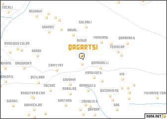
Qağartsi (Xocavǝnd, Azerbaijan)Qağartsi is a town in the Xocavǝnd region of Azerbaijan. An overview map of the region around Qağartsi is displayed below.
regional and 3d topo map of Qağartsi, Azerbaijan ::
Qağartsi airports ::
The nearest airport is TBZ - Tabriz Intl, located 196.4 km south of Qağartsi.
Nearby towns ::
Paravatumb (1.1km south) //
Avdur (3.2km north) //
Hatsi (3.6km north east) //
Miruşen (3.6km north west) //
Qaradağlı (3.5km south east) //
Kǝndxurd (4.5km south east) //
Yenikǝnd (5.0km north east) //
Abdal (5.8km north) //
Cǝmiyyǝt (5.1km south west) //
Gavahın (6.1km south) //
Müşkapat (5.8km south east) //
Arpadüzü (7.1km south) //
Heşan (5.9km north east) //
Gülablı (7.3km north) //
Yemişcan (6.2km east) //
Ağbulaq (8.1km south) //
Ağbulaq (7.8km north west) //
Ağkǝnd (6.6km east) //
Kiş (8.1km south east) //
Dǝhrǝz (8.6km north west) //
Quzumkǝnd (9.4km south east) //
Xaçmaç (9.0km south west) //
Aranzǝmin (9.8km north west) //
Güneyçartar (9.2km south east) //
[all distances 'as the bird flies' and approximate] 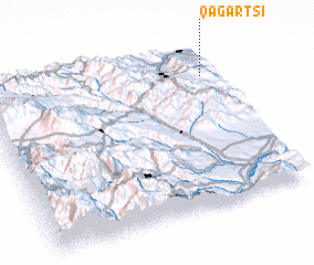 Places with similar names to Qağartsi, Azerbaijan ::
// Köckritz (DE)
// Kokortsi (BG)
// Çakartaş (TR)
// Çakırtaş (TR)
// Çakırtaş (TR)
// Koukouroutazou (GN)
// Kaukaritsa (FI)
// Kokártza (GR)
Disclaimer :: Information on this page comes without warranty of any kind |
||
|
Where is Qağartsi? Elevation and coordinates ::
Latitude (lat): 39°48'54"N Longitude (lon): 46°56'29"E
Elevation (approx.): 878m (map arrows pan, magnifying glasses zoom) |
||
|
Visiting Qağartsi? Hotel/Accommodation ::
Book a hotel in Qağartsi Travel Guide ::
Buy a travel guide for Azerbaijan rental cars ::
car rental offers GPS waypoint ::
download a GPX waypoint (PoI) of Qağartsi for your GPS receiver
|
||