|
search place name
|
||
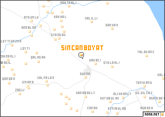
Sincanboyat (Dǝvǝçi, Azerbaijan)Sincanboyat is a town in the Dǝvǝçi region of Azerbaijan. An overview map of the region around Sincanboyat is displayed below.
regional and 3d topo map of Sincanboyat, Azerbaijan ::
Sincanboyat airports ::
The nearest airport is BAK - Baku Heydar Aliyev, located 124.2 km south east of Sincanboyat.
Other airports nearby include MCX - Makhachkala Uytash (207.6 km north west), Nearby towns ::
Allahyarlı (2.5km north east) //
Dǝvǝçi (2.5km south east) //
Kuybışevkǝnd (3.2km north west) //
Surra (4.4km south) //
(( Gyulamli )) (5.3km east) //
Gyandov (6.1km north west) //
Mǝliklǝr (6.9km north west) //
Gǝndov (6.4km north west) //
Xǝlilli (8.5km north) //
Karabagly (8.6km south) //
Uzunboyat (8.1km north west) //
(( Baladzha Shakhnazarli )) (8.1km north west) //
Ashagy Emirkhanly (8.8km south west) //
Sarvan (8.4km north east) //
Dzheyranly (9.2km south) //
Xǝlfǝlǝr (8.1km south west) //
Yelǝkǝsǝn (8.4km south west) //
(( Kakhal )) (9.4km north west) //
[all distances 'as the bird flies' and approximate]  Places with similar names to Sincanboyat, Azerbaijan :: Disclaimer :: Information on this page comes without warranty of any kind |
||
|
Where is Sincanboyat? Elevation and coordinates ::
Latitude (lat): 41°13'20"N Longitude (lon): 48°57'38"E
Elevation (approx.): 27m (map arrows pan, magnifying glasses zoom) |
||
|
Visiting Sincanboyat? Hotel/Accommodation ::
Book a hotel in Sincanboyat Travel Guide ::
Buy a travel guide for Azerbaijan rental cars ::
car rental offers GPS waypoint ::
download a GPX waypoint (PoI) of Sincanboyat for your GPS receiver
|
||