|
search place name
|
||
Xoşçobanli (İmişli, Azerbaijan)Xoşçobanli is a town in the İmişli region of Azerbaijan. An overview map of the region around Xoşçobanli is displayed below.
regional and 3d topo map of Xoşçobanli, Azerbaijan ::

Xoşçobanli airports ::
The nearest airport is BAK - Baku Heydar Aliyev, located 177.5 km north east of Xoşçobanli.
Other airports nearby include TBZ - Tabriz Intl (251.4 km south west), Nearby towns ::
Khanlykh-Dzhevat (1.6km north) //
Murquzalılı (2.3km east) //
Dzhavadkhanly (3.4km north) //
Nurulu (3.8km south) //
Qaralar (3.9km north) //
Muradalılı (3.9km south) //
Otuziki (3.2km west) //
Qaralar (4.5km south west) //
Olcalar (5.7km south west) //
Yalavadzh (5.3km south west) //
İmişli (5.7km west) //
Soltanmuradly (6.9km south west) //
Gëkharli (6.7km south west) //
Bǝcirǝvan (7.2km north east) //
Mürsǝlli (6.2km east) //
Qulubǝyli (8.7km south) //
Mamedli (7.5km south west) //
Chakhar (8.3km south west) //
Agdzhuvur (8.3km north east) //
[all distances 'as the bird flies' and approximate] 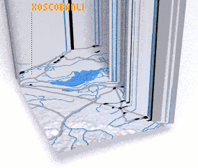 Places with similar names to Xoşçobanli, Azerbaijan :: Disclaimer :: Information on this page comes without warranty of any kind |
||
|
Where is Xoşçobanli? Elevation and coordinates ::
Latitude (lat): 39°51'12"N Longitude (lon): 48°7'25"E
Elevation (approx.): -4m (map arrows pan, magnifying glasses zoom) |
||
|
Visiting Xoşçobanli? Hotel/Accommodation ::
Book a hotel in Xoşçobanli Travel Guide ::
Buy a travel guide for Azerbaijan rental cars ::
car rental offers GPS waypoint ::
download a GPX waypoint (PoI) of Xoşçobanli for your GPS receiver
|
||