|
search place name
|
||
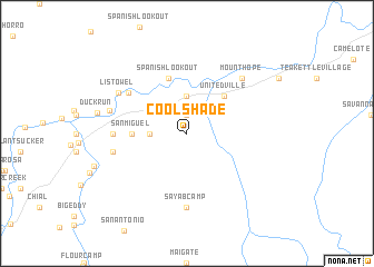
Cool Shade (Cayo, Belize)Cool Shade is a town in the Cayo region of Belize. An overview map of the region around Cool Shade is displayed below.
regional and 3d topo map of Cool Shade, Belize ::
Cool Shade airports ::
The nearest airport is BZE - Belize City Philip S W Goldson Intl, located 81.2 km north east of Cool Shade.
Other airports nearby include CTM - Chetumal Intl (162.9 km north east), SAP - San Pedro Sula La Mesa Intl (220.0 km south east), TEA - Tela (221.4 km south east), CBV - Coban (242.9 km south west), Nearby towns ::
Georgeville (1.9km north) //
Norland (3.5km west) //
Barton Ramie (3.7km north) //
Unitedville (5.1km north east) //
San Miguel (5.3km west) //
Spanish Lookout (5.8km north) //
Baking Pot (6.9km north west) //
Esperanza (7.1km west) //
Sayab Camp (7.4km south) //
Pilgrimage Valley (7.3km west) //
Mount Hope (7.7km north east) //
Iguana Creek Bank (7.7km north east) //
Black Man Eddy (7.7km north east) //
Listowel (7.7km north west) //
Benque Ceiba (7.8km west) //
[all distances 'as the bird flies' and approximate]  Places with similar names to Cool Shade, Belize ::
Disclaimer :: Information on this page comes without warranty of any kind |
||
|
Where is Cool Shade? Elevation and coordinates ::
Latitude (lat): 17°10'0"N Longitude (lon): 88°58'0"W
Elevation (approx.): 84m (map arrows pan, magnifying glasses zoom) |
||
|
Visiting Cool Shade? Hotel/Accommodation ::
Book a hotel in Cool Shade Travel Guide ::
Buy a travel guide for Belize rental cars ::
car rental offers GPS waypoint ::
download a GPX waypoint (PoI) of Cool Shade for your GPS receiver
|
||