|
search place name
|
||
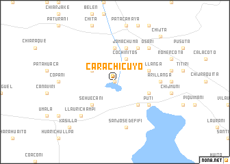
Carachicuyo (La Paz, Bolivia)Carachicuyo is a town in the La Paz region of Bolivia. An overview map of the region around Carachicuyo is displayed below.
regional and 3d topo map of Carachicuyo, Bolivia ::
Carachicuyo airports ::
The nearest airport is LPB - La Paz El Alto Intl, located 93.1 km north of Carachicuyo.
Other airports nearby include CBB - Cochabamba Jorge Wilsterman (187.0 km east), Nearby towns ::
Jachasirca (0.0km north) //
Cochinitos (4.1km north east) //
Cañaviri (4.0km north west) //
Villa Romero (4.0km north west) //
Huacachinuña (5.1km south east) //
Sehuecani (5.1km south west) //
Iquiaca (5.6km north) //
Tolacica (5.6km east) //
Jamachuma (5.8km north) //
Taipillanga (5.6km east) //
Culta (6.6km north east) //
Puti (6.5km south east) //
Arillanga (7.1km east) //
San José de Fifi (7.6km south) //
Llaurichampi (7.7km south west) //
Osari (7.7km north east) //
Tuluma (7.7km south west) //
Kasilla (10.2km south west) //
Chijta (10.2km north east) //
[all distances 'as the bird flies' and approximate] 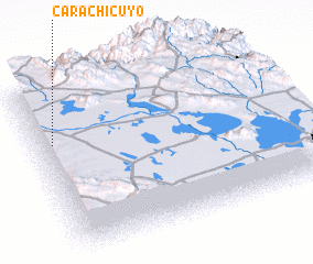 Places with similar names to Carachicuyo, Bolivia ::
// Karachakiya (UZ)
// Karashkūyeh (IR)
Disclaimer :: Information on this page comes without warranty of any kind |
||
|
Where is Carachicuyo? Elevation and coordinates ::
Latitude (lat): 17°19'0"S Longitude (lon): 67°56'0"W
Elevation (approx.): 3760m (map arrows pan, magnifying glasses zoom) |
||
|
Visiting Carachicuyo? Hotel/Accommodation ::
Book a hotel in Carachicuyo Travel Guide ::
Buy a travel guide for Bolivia rental cars ::
car rental offers GPS waypoint ::
download a GPX waypoint (PoI) of Carachicuyo for your GPS receiver
|
||